|
search place name
|
||
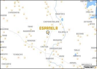
Espanela (Inhambane, Mozambique)Espanela is a town in the Inhambane region of Mozambique. An overview map of the region around Espanela is displayed below.
regional and 3d topo map of Espanela, Mozambique ::
Espanela airports ::
The nearest airport is VNX - Vilankulu Vilankulo, located 29.4 km south east of Espanela.
Nearby towns ::
Uaque (1.1km south west) //
Faquir Jiva (3.1km south west) //
Chefe Maimelane (4.0km north) //
Malangute (4.3km south) //
Paindano (4.8km south east) //
Chamuço (5.2km south east) //
Mabulacuacha (5.3km south east) //
Pula-Pula (5.3km east) //
Chamuço (5.8km north east) //
Castigo (6.0km south) //
Jaquissene (5.8km north east) //
Sechene (6.6km south) //
Maela (6.4km west) //
Taime (6.7km west) //
Vamequinque (7.2km south east) //
Semende (6.9km south west) //
Mudarroupa (6.9km west) //
Uatele (7.6km north) //
Fadecuane (7.5km south) //
Sòzinho (7.8km south) //
Manabalate (7.6km south west) //
Chefe Checane (8.0km north) //
Bacela (7.8km south west) //
Ind. V. Uacheze (7.7km east) //
Magatane (8.1km north east) //
Cabo Mugonze (8.5km south east) //
Mueoane (8.0km west) //
Maimelane (8.9km north) //
Tiano (8.6km south west) //
[all distances 'as the bird flies' and approximate] 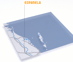 Places with similar names to Espanela, Mozambique ::
// Espanola (US)
// Espinal (CU)
// Espanillo (ES)
// Espiniella (ES)
// Espiniella (ES)
// Espinilla (ES)
// Espanola (US)
// Espanola (US)
// Espinal (CO)
// Espinal (CO)
Disclaimer :: Information on this page comes without warranty of any kind |
||
|
Where is Espanela? Elevation and coordinates ::
Latitude (lat): 21°50'3"S Longitude (lon): 35°6'31"E
Elevation (approx.): 20m (map arrows pan, magnifying glasses zoom) |
||
|
Visiting Espanela? Hotel/Accommodation ::
Book a hotel in Espanela Travel Guide ::
Buy a travel guide for Mozambique rental cars ::
car rental offers GPS waypoint ::
download a GPX waypoint (PoI) of Espanela for your GPS receiver
|
||