|
search place name
|
||
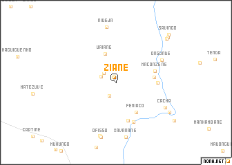
Ziane (Gaza, Mozambique)Ziane is a town in the Gaza region of Mozambique. An overview map of the region around Ziane is displayed below.
regional and 3d topo map of Ziane, Mozambique ::
Ziane airports ::
The nearest airport is BFO - Chiredzi Buffalo Range, located 229.3 km north west of Ziane.
Nearby towns ::
Piquissai (2.4km south west) //
Chigodo (2.4km north west) //
Mutavane (2.4km west) //
Uaiane (4.9km north) //
Femiaco (5.7km south east) //
Muachevane (5.8km east) //
Justino (6.4km south) //
Maconzene (6.1km east) //
Josefo (6.3km east) //
Mafucaiane (6.9km south) //
Ongonde (7.8km north east) //
Cacha (8.4km south east) //
Xavanane (9.0km south) //
Deimane (9.0km south) //
Macaúle (9.3km south east) //
Tenda (10.4km north east) //
Chefe Manguale (10.7km north east) //
Savingo (11.1km north east) //
[all distances 'as the bird flies' and approximate] 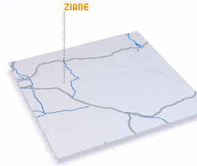 Places with similar names to Ziane, Mozambique ::
Disclaimer :: Information on this page comes without warranty of any kind |
||
|
Where is Ziane? Elevation and coordinates ::
Latitude (lat): 22°19'13"S Longitude (lon): 33°17'34"E
Elevation (approx.): 111m (map arrows pan, magnifying glasses zoom) |
||
|
Visiting Ziane? Hotel/Accommodation ::
Book a hotel in Ziane Travel Guide ::
Buy a travel guide for Mozambique rental cars ::
car rental offers GPS waypoint ::
download a GPX waypoint (PoI) of Ziane for your GPS receiver
|
||