|
search place name
|
||
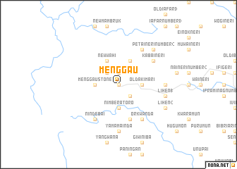
Menggau (Sandaun, Papua New Guinea)Menggau is a town in the Sandaun region of Papua New Guinea. An overview map of the region around Menggau is displayed below.
regional and 3d topo map of Menggau, Papua New Guinea ::
Menggau airports ::
The nearest airport is DJJ - Jayapura Sentani, located 127.7 km north west of Menggau.
Nearby towns ::
Tamarbek (0.0km north) //
New Kamberatoro (0.0km north) //
New Menggau (1.9km north) //
Wagarinda (2.6km north west) //
Old Kamberatoro (2.6km south east) //
Wahi (2.6km north west) //
Akimari Number 1 (3.7km east) //
Old Akimari (3.7km east) //
Nimberatoro (3.7km south) //
Menggau Stone (3.7km west) //
New Wahi (4.1km north west) //
Akimari Number 2 (4.1km north east) //
Mongrovei (5.9km south) //
Kabaineri (6.7km north east) //
Orkwanda (6.7km south east) //
Petaineri Number 1 (6.7km north east) //
Mamambra (6.7km south west) //
Nindebai (6.7km south west) //
Kwofinau (7.4km east) //
New Naineri (7.4km east) //
Yamamainda (7.4km south) //
Lihen 1 (7.6km east) //
Petaineri Number 2 (7.9km north east) //
Lihen 2 (8.3km south east) //
[all distances 'as the bird flies' and approximate] 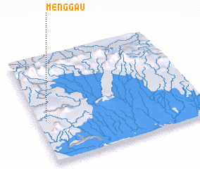 Places with similar names to Menggau, Papua New Guinea ::
Disclaimer :: Information on this page comes without warranty of any kind |
||
|
Where is Menggau? Elevation and coordinates ::
Latitude (lat): 3°36'0"S Longitude (lon): 141°3'0"E
Elevation (approx.): 417m (map arrows pan, magnifying glasses zoom) |
||
|
Visiting Menggau? Hotel/Accommodation ::
Book a hotel in Menggau Travel Guide ::
rental cars ::
car rental offers GPS waypoint ::
download a GPX waypoint (PoI) of Menggau for your GPS receiver
|
||