|
search place name
|
||
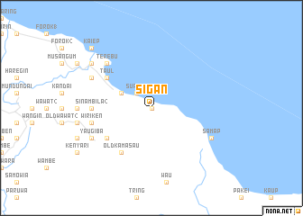
Sigan (Papua New Guinea)Sigan is a town in Papua New Guinea. An overview map of the region around Sigan is displayed below.
regional and 3d topo map of Sigan, Papua New Guinea ::
Sigan airports ::
The nearest airport is WWK - Wewak Intl, located 25.4 km north west of Sigan.
Other airports nearby include MAG - Madang (270.7 km south east), Nearby towns ::
Sil (0.0km north) //
Suanam (2.6km north west) //
Munjun (4.1km north west) //
Kamasau (6.7km south west) //
Murrai (6.7km south west) //
Taul (6.7km north west) //
Old Kamasau (6.7km south west) //
Sinambila 2 (7.4km west) //
Wiriken (7.6km west) //
Terebu (7.9km north west) //
Samap (8.3km south east) //
Yaugiba (8.3km south west) //
Bungain (8.3km north west) //
Dagawat (9.3km north west) //
Balik (9.3km north west) //
Kaiep (10.5km north west) //
[all distances 'as the bird flies' and approximate] 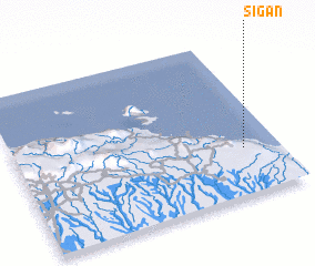 Places with similar names to Sigan, Papua New Guinea ::
Disclaimer :: Information on this page comes without warranty of any kind |
||
|
Where is Sigan? Elevation and coordinates ::
Latitude (lat): 3°42'0"S Longitude (lon): 143°52'0"E
Elevation (approx.): 191m (map arrows pan, magnifying glasses zoom) |
||
|
Visiting Sigan? Hotel/Accommodation ::
Book a hotel in Sigan Travel Guide ::
rental cars ::
car rental offers GPS waypoint ::
download a GPX waypoint (PoI) of Sigan for your GPS receiver
|
||