|
search place name
|
||
Vunadavai (Papua New Guinea)Vunadavai is a town in Papua New Guinea. An overview map of the region around Vunadavai is displayed below.
regional and 3d topo map of Vunadavai, Papua New Guinea ::

Nearby towns ::
Rambabat (0.0km north) //
Tovakundum (1.8km east) //
Natava (1.8km west) //
Livuan (1.8km west) //
Volavolo (3.7km south) //
Ratongor (3.7km east) //
Mailivuan (4.1km south west) //
Vunalir (4.1km south east) //
Liguan (4.1km south west) //
Lungalunga (4.1km south west) //
Raluana (5.2km south east) //
Rasimen (5.6km south) //
Putanagororoi (5.5km east) //
Kabaira (5.9km south) //
Rakanda (6.7km south east) //
Toboina (6.7km south east) //
Vunairoto (7.4km east) //
Nabata (7.6km east) //
Vunabuk (8.3km north east) //
Ulagio (8.3km north east) //
Totovel (9.3km south east) //
Vunapaka (9.3km south east) //
Vunatokukup (9.3km south east) //
Kikitambu (10.5km south east) //
[all distances 'as the bird flies' and approximate] 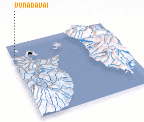 Places with similar names to Vunadavai, Papua New Guinea ::
// Vandovo (RU)
// Ventava (LV)
// Fundu Văii (RO)
// Fundu Văii (RO)
// Fundu Văii (RO)
// Fandiova (MG)
// Fintefa (ID)
// Vunatovau (FJ)
// Vindevu (MW)
Disclaimer :: Information on this page comes without warranty of any kind |
||
|
Where is Vunadavai? Elevation and coordinates ::
Latitude (lat): 4°12'0"S Longitude (lon): 152°1'0"E
Elevation (approx.): 72m (map arrows pan, magnifying glasses zoom) |
||
|
Visiting Vunadavai? Hotel/Accommodation ::
Book a hotel in Vunadavai Travel Guide ::
rental cars ::
car rental offers GPS waypoint ::
download a GPX waypoint (PoI) of Vunadavai for your GPS receiver
|
||