|
search place name
|
||
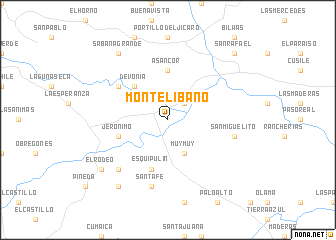
Monte Líbano (Matagalpa, Nicaragua)Monte Líbano is a town in the Matagalpa region of Nicaragua. An overview map of the region around Monte Líbano is displayed below.
regional and 3d topo map of Monte Líbano, Nicaragua ::
Monte Líbano airports ::
The nearest airport is MGA - Managua Intl, located 92.1 km south west of Monte Líbano.
Other airports nearby include TGU - Tegucigalpa Toncontin Intl (219.7 km north west), BEF - Bluefields (222.8 km south east), Nearby towns ::
El Esquirín (2.6km north east) //
Muy Muy (4.1km south east) //
Devonia (5.2km north west) //
Asancor (5.6km north) //
Esquipulín (5.8km south) //
Jerónimo (5.7km west) //
San Marcos (6.6km north west) //
Santa Fe (7.6km south) //
San Miguelito (7.5km east) //
El Paraíso (7.8km south west) //
Sabana Grande (9.2km north west) //
El Gorrión (9.2km south west) //
El Rodeo (9.1km south west) //
San Rafael (10.4km north east) //
[all distances 'as the bird flies' and approximate]  Places with similar names to Monte Líbano, Nicaragua ::
// Montalbano (IT)
// Montalbano (IT)
// Montalbán (ES)
// Montelíbano (CO)
// Montelíbano (CO)
// Monte Líbano (MX)
// Monte Libano (MX)
// Montalban (VE)
// Montalbán (VE)
// Montalbán (VE)
Disclaimer :: Information on this page comes without warranty of any kind |
||
|
Where is Monte Líbano? Elevation and coordinates ::
Latitude (lat): 12°48'0"N Longitude (lon): 85°39'0"W
Elevation (approx.): 305m (map arrows pan, magnifying glasses zoom) |
||
|
Visiting Monte Líbano? Hotel/Accommodation ::
Book a hotel in Monte Líbano Travel Guide ::
Buy a travel guide for Nicaragua rental cars ::
car rental offers GPS waypoint ::
download a GPX waypoint (PoI) of Monte Líbano for your GPS receiver
|
||