|
search place name
|
||
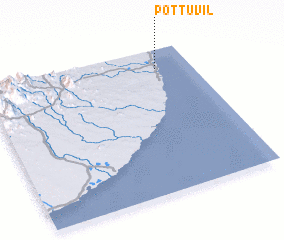
Pottuvil (North Eastern, Sri Lanka)Pottuvil is a town in the North Eastern region of Sri Lanka. An overview map of the region around Pottuvil is displayed below.
regional and 3d topo map of Pottuvil, Sri Lanka ::

Pottuvil airports ::
The nearest airport is GOY - Galoya Amparai, located 56.8 km north west of Pottuvil.
Other airports nearby include TRR - Trinciomalee China Bay (198.4 km north), RML - Colombo Ratmalana (215.3 km west), CMB - Bandaranaike Intl Colombo (218.2 km west), Nearby towns ::
 Places with similar names to Pottuvil, Sri Lanka ::
// Pettville (BZ)
// Pettyville (US)
// Pateville (US)
// Podval (BA)
// Peatville (US)
// Pittville (US)
// Puduveli (IN)
// Putuveli (LK)
// Putuveli (LK)
// Pie de Filo (VE)
Disclaimer :: Information on this page comes without warranty of any kind |
||
|
Where is Pottuvil? Elevation and coordinates ::
Latitude (lat): 6°52'0"N Longitude (lon): 81°50'0"E
Elevation (approx.): 8m (map arrows pan, magnifying glasses zoom) |
||
|
Visiting Pottuvil? Hotel/Accommodation ::
Book a hotel in Pottuvil Travel Guide ::
Buy a travel guide for Sri Lanka rental cars ::
car rental offers GPS waypoint ::
download a GPX waypoint (PoI) of Pottuvil for your GPS receiver
|
||