|
search place name
|
||
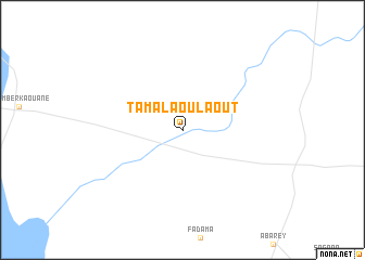
Tamalaoulaout (Niamey, Niger)Tamalaoulaout is a town in the Niamey region of Niger. An overview map of the region around Tamalaoulaout is displayed below.
regional and 3d topo map of Tamalaoulaout, Niger ::
Tamalaoulaout airports ::
The nearest airport is THZ - Tahoua, located 171.7 km east of Tamalaoulaout.
Other airports nearby include NIM - Niamey Diori Hamani (249.4 km south west), Nearby towns ::
[all distances 'as the bird flies' and approximate]  Places with similar names to Tamalaoulaout, Niger ::
// Tamelelt (MA)
// Tamellalt (MA)
// Tamellalt (MA)
// Tamlelt (MA)
// Timelilt (MA)
// Timlilt (MA)
// Tombalilatu (ID)
// Tombulilata (ID)
// Tombulilato (ID)
// Tamelalt (MA)
Disclaimer :: Information on this page comes without warranty of any kind |
||
|
Where is Tamalaoulaout? Elevation and coordinates ::
Latitude (lat): 15°11'0"N Longitude (lon): 3°42'0"E
Elevation (approx.): 261m (map arrows pan, magnifying glasses zoom) |
||
|
Visiting Tamalaoulaout? Hotel/Accommodation ::
Book a hotel in Tamalaoulaout Travel Guide ::
Buy a travel guide for Niger rental cars ::
car rental offers GPS waypoint ::
download a GPX waypoint (PoI) of Tamalaoulaout for your GPS receiver
|
||