|
search place name
|
||
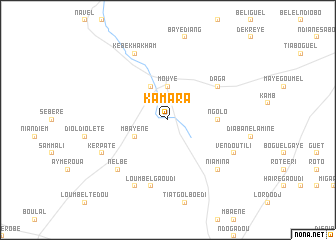
Kamara (Louga, Senegal)Kamara is a town in the Louga region of Senegal. An overview map of the region around Kamara is displayed below.
regional and 3d topo map of Kamara, Senegal ::
Kamara airports ::
The nearest airport is XLS - St. Louis Saint Louis, located 115.8 km north west of Kamara.
Other airports nearby include KLC - Kaolack (161.5 km south), DKR - Dakar Leopold Sedar Senghor Intl (227.2 km west), TUD - Tambacounda (282.5 km south east), Nearby towns ::
Mouye (3.7km north) //
Malème (4.1km north west) //
Mbayène (4.0km south west) //
Ngolo (5.4km east) //
Daga (6.5km north east) //
Loumbel Gaoudi (7.6km south) //
Nelbè (7.7km south west) //
Niamina (7.7km south east) //
Kébé Khakham (8.2km north west) //
Mbèyélone (8.0km south east) //
Vèndou Tili (8.0km south east) //
Kerpaté (8.0km south west) //
Keur Simbing (8.2km south west) //
[all distances 'as the bird flies' and approximate] 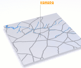 Places with similar names to Kamara, Senegal ::
Disclaimer :: Information on this page comes without warranty of any kind |
||
|
Where is Kamara? Elevation and coordinates ::
Latitude (lat): 15°31'0"N Longitude (lon): 15°32'0"W
Elevation (approx.): 27m (map arrows pan, magnifying glasses zoom) |
||
|
Visiting Kamara? Hotel/Accommodation ::
Book a hotel in Kamara Travel Guide ::
Buy a travel guide for Senegal rental cars ::
car rental offers GPS waypoint ::
download a GPX waypoint (PoI) of Kamara for your GPS receiver
|
||