|
search place name
|
||
Chituta (Western, Zambia)Chituta is a town in the Western region of Zambia. An overview map of the region around Chituta is displayed below.
regional and 3d topo map of Chituta, Zambia ::
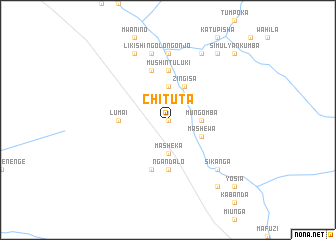
Nearby towns ::
Nyundu (NaNkm north) //
Mungomba (3.6km east) //
Masheka (3.7km south) //
Lifweba (3.7km north) //
Nasishemo (3.7km north) //
Zingisa (4.1km north east) //
Manjolo (4.1km north east) //
Mashewa (4.0km south east) //
Kakupa (4.0km south east) //
Chilanda (5.6km north) //
Liwema (5.6km north) //
Mushintuluki (5.6km north) //
Lumai (5.4km west) //
Ngandalo (5.6km south) //
Mungomba (5.8km south) //
Kaliki (5.8km north) //
Ngolongonjo (7.4km north) //
Leleka (7.6km north) //
Kambole (7.6km north) //
Mankata (7.6km north) //
Sikanga (7.7km south east) //
Makina (7.7km south east) //
Muvuli (8.2km north east) //
Njenjema (8.2km north east) //
Litakamulilo (8.2km north west) //
Likishi (8.2km north west) //
Sifweti (9.2km north east) //
Sitenda (9.1km south east) //
Yosia (10.3km south east) //
[all distances 'as the bird flies' and approximate]  Places with similar names to Chituta, Zambia ::
// Chiatat (MA)
// Tiouddit (MA)
// Shadowwood (US)
// Chitid (RO)
// Chododa (RU)
// Shadīdah (IQ)
// Chāh Tūt (IR)
// Shadow Wood (US)
// Shadow Wood (US)
// Chhātādda (BD)
Disclaimer :: Information on this page comes without warranty of any kind |
||
|
Where is Chituta? Elevation and coordinates ::
Latitude (lat): 15°15'0"S Longitude (lon): 24°37'0"E
Elevation (approx.): 1160m (map arrows pan, magnifying glasses zoom) |
||
|
Visiting Chituta? Hotel/Accommodation ::
Book a hotel in Chituta Travel Guide ::
Buy a travel guide for Zambia rental cars ::
car rental offers GPS waypoint ::
download a GPX waypoint (PoI) of Chituta for your GPS receiver
|
||