|
search place name
|
||
Muliwana (Western, Zambia)Muliwana is a town in the Western region of Zambia. An overview map of the region around Muliwana is displayed below.
regional and 3d topo map of Muliwana, Zambia ::
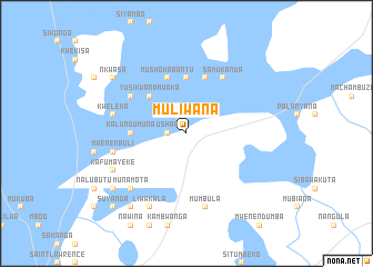
Nearby towns ::
Ushaa (1.8km west) //
Yusikwanamwaka (5.2km north west) //
Kalundumuna (5.4km west) //
Luyanga (5.6km north) //
Nambwengo (5.6km north) //
Mushokabantu (5.8km north) //
Mutanuko (5.8km north) //
Ngenda (6.5km north west) //
Samukanda (6.6km north east) //
Kweleka (7.4km west) //
Mwenemauli (7.4km west) //
Kuakua (7.4km west) //
Mumbula (7.6km south) //
Munamota (7.7km south west) //
Kafumayeke (8.1km south west) //
Kaputi (8.2km south west) //
Liwakala (8.2km south west) //
Nkwasa (9.1km north west) //
Mwiya (9.1km south west) //
Mukuwa (9.2km south west) //
Mwenda (9.2km south west) //
Suyanda (10.3km south west) //
[all distances 'as the bird flies' and approximate] 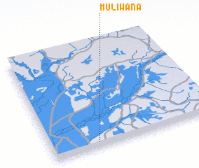 Places with similar names to Muliwana, Zambia ::
Disclaimer :: Information on this page comes without warranty of any kind |
||
|
Where is Muliwana? Elevation and coordinates ::
Latitude (lat): 14°57'0"S Longitude (lon): 23°17'0"E
Elevation (approx.): 1029m (map arrows pan, magnifying glasses zoom) |
||
|
Visiting Muliwana? Hotel/Accommodation ::
Book a hotel in Muliwana Travel Guide ::
Buy a travel guide for Zambia rental cars ::
car rental offers GPS waypoint ::
download a GPX waypoint (PoI) of Muliwana for your GPS receiver
|
||