|
search place name
|
||
Munamota (Western, Zambia)Munamota is a town in the Western region of Zambia. An overview map of the region around Munamota is displayed below.
regional and 3d topo map of Munamota, Zambia ::
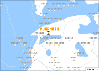
Nearby towns ::
Mwiya (1.8km west) //
Mwenda (1.9km south) //
Mukuwa (1.9km south) //
Kafumayeke (2.6km north west) //
Suyanda (2.6km south west) //
Kaputi (2.6km south east) //
Liwakala (2.6km south east) //
Nawina (3.7km south) //
Nalubutu (3.6km west) //
Mwenemauli (4.1km north west) //
Mubanda (4.1km south east) //
Sianga (4.0km south west) //
Nahongo (4.0km south west) //
Lukama (5.2km north west) //
Kambwanga (5.2km south east) //
Kalundumuna (5.6km north) //
Ushaa (6.6km north east) //
Kuakua (7.6km north) //
Kweleka (7.6km north) //
Mumbula (7.4km east) //
Muliwana (7.7km north east) //
Muhale (7.7km south west) //
Mombo (9.1km south west) //
Sakanga (9.1km south west) //
Mukenamongi (9.2km south west) //
Koyana (10.3km south west) //
Saint Lawrence (10.3km south west) //
[all distances 'as the bird flies' and approximate] 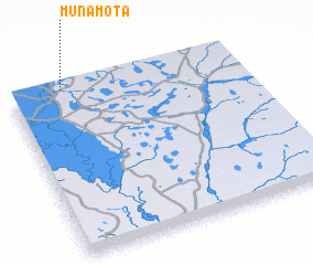 Places with similar names to Munamota, Zambia ::
// Mān Maw-wēt (MM)
// Mān Müt (MM)
// Mān Namhtū (MM)
// Mān Namta (MM)
// Mān Namtai (MM)
// Mān Namtao (MM)
// Mān Namte (MM)
// Manaomata (PH)
// Manambato (MG)
// Manambato (MG)
Disclaimer :: Information on this page comes without warranty of any kind |
||
|
Where is Munamota? Elevation and coordinates ::
Latitude (lat): 15°0'0"S Longitude (lon): 23°14'0"E
Elevation (approx.): 1036m (map arrows pan, magnifying glasses zoom) |
||
|
Visiting Munamota? Hotel/Accommodation ::
Book a hotel in Munamota Travel Guide ::
Buy a travel guide for Zambia rental cars ::
car rental offers GPS waypoint ::
download a GPX waypoint (PoI) of Munamota for your GPS receiver
|
||