|
search place name
|
||
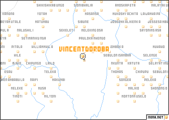
Vincent Doroba (Central, Zambia)Vincent Doroba is a town in the Central region of Zambia. An overview map of the region around Vincent Doroba is displayed below.
regional and 3d topo map of Vincent Doroba, Zambia ::
Vincent Doroba airports ::
The nearest airport is MFU - Mfuwe, located 125.4 km east of Vincent Doroba.
Nearby towns ::
Serenje (0.0km north) //
Nachibesa (1.9km north) //
Yotam Bulaya (2.6km north east) //
Mambwe Chilwele (4.1km north east) //
Nabwale (4.1km north east) //
Paulo Kamwendo (4.1km north east) //
Dixon Malwita (5.2km north east) //
Chiputwa (5.2km north east) //
Namiselo (5.7km east) //
Yotam Wasomboka (5.7km east) //
Mateyo Botolo (5.7km east) //
James Mofia (5.8km north) //
Meleki Ngosa (5.8km north) //
Sekeleti (6.6km north west) //
Sibune (7.4km north) //
Sebuloni Sambwa (7.2km east) //
Lailo (7.5km west) //
Philipo Katola (7.6km north) //
Jeki (7.6km north) //
Nkunta (7.5km east) //
Makumbi (7.8km south west) //
Teleka (8.1km south west) //
Mesheka (8.1km south east) //
Nabwale (8.1km south east) //
Sululu (8.1km south east) //
Thomas (8.1km south east) //
Mesa (9.1km south east) //
Chipalashi (10.3km south east) //
[all distances 'as the bird flies' and approximate]  Places with similar names to Vincent Doroba, Zambia :: Disclaimer :: Information on this page comes without warranty of any kind |
||
|
Where is Vincent Doroba? Elevation and coordinates ::
Latitude (lat): 13°10'0"S Longitude (lon): 30°47'0"E
Elevation (approx.): 1454m (map arrows pan, magnifying glasses zoom) |
||
|
Visiting Vincent Doroba? Hotel/Accommodation ::
Book a hotel in Vincent Doroba Travel Guide ::
Buy a travel guide for Zambia rental cars ::
car rental offers GPS waypoint ::
download a GPX waypoint (PoI) of Vincent Doroba for your GPS receiver
|
||