|
search place name
|
||
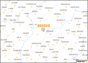
Baraka (Southern, Sierra Leone)Baraka is a town in the Southern region of Sierra Leone. An overview map of the region around Baraka is displayed below.
regional and 3d topo map of Baraka, Sierra Leone ::
Baraka airports ::
The nearest airport is MLW - Monrovia Spriggs Payne, located 173.3 km south east of Baraka.
Other airports nearby include FNA - Freetown Lungi (204.6 km north west), ROB - Monrovia Roberts Intl (206.2 km south east), Nearby towns ::
Bandajuma (1.8km north east) //
Gomahun (2.8km east) //
Nyeyama (2.8km north west) //
Gandorhun (3.1km west) //
Faiama (4.8km north) //
Dina (5.8km west) //
Maka (5.9km south) //
Bamata (6.7km south east) //
Jeoma Jago (7.0km south west) //
Pehala (7.2km south east) //
Masau (7.4km south) //
Naiagolehun (7.4km north west) //
Faiama (7.6km west) //
Gombu (8.3km north west) //
Pejewulu (8.2km north east) //
Pewama (8.2km south east) //
Jeoma (8.4km south west) //
Komendi (8.6km north east) //
Yandehun (9.1km north) //
Baka (9.4km south) //
Jama (9.7km north west) //
Konela (10.7km south east) //
Gigbema (11.6km north east) //
[all distances 'as the bird flies' and approximate] 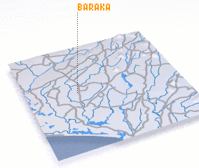 Places with similar names to Baraka, Sierra Leone ::
Disclaimer :: Information on this page comes without warranty of any kind |
||
|
Where is Baraka? Elevation and coordinates ::
Latitude (lat): 7°34'0"N Longitude (lon): 11°40'0"W
Elevation (approx.): 63m (map arrows pan, magnifying glasses zoom) |
||
|
Visiting Baraka? Hotel/Accommodation ::
Book a hotel in Baraka Travel Guide ::
rental cars ::
car rental offers GPS waypoint ::
download a GPX waypoint (PoI) of Baraka for your GPS receiver
|
||