|
search place name
|
||
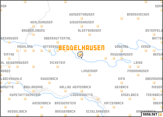
Beddelhausen (Nordrhein-Westfalen, Germany)Beddelhausen is a town in the Nordrhein-Westfalen region of Germany. An overview map of the region around Beddelhausen is displayed below.
regional and 3d topo map of Beddelhausen, Germany ::
Beddelhausen airports ::
The nearest airport is ZCA - Arnsberg Menden, located 68.2 km north west of Beddelhausen.
Other airports nearby include PAD - Paderborn Lippstadt (68.8 km north), KSF - Kassel Calden (76.3 km north east), DTM - Dortmund (84.6 km north west), CGN - Cologne Koln Bonn (96.6 km west), Nearby towns ::
Elsoff (1.9km north) //
Schwarzenau (3.0km north west) //
Lindenhof (3.9km south) //
Ebenfeld (3.5km east) //
Hatzfeld (3.5km east) //
Alertshausen (5.7km north) //
Untere Hüttental (4.0km north west) //
Richstein (4.0km south west) //
Obere Hüttental (5.1km north west) //
Weifenbach (7.4km south) //
Diedenshausen (7.4km north) //
Biebighausen (4.7km east) //
Arfeld (5.0km west) //
Dachsloch (7.8km north) //
Wallau (7.8km south) //
Puderbach (7.3km south west) //
[all distances 'as the bird flies' and approximate] 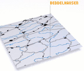 Places with similar names to Beddelhausen, Germany ::
Disclaimer :: Information on this page comes without warranty of any kind |
||
|
Where is Beddelhausen? Elevation and coordinates ::
Latitude (lat): 51°0'0"N Longitude (lon): 8°30'0"E
Elevation (approx.): 418m (map arrows pan, magnifying glasses zoom) |
||
|
Visiting Beddelhausen? Hotel/Accommodation ::
Book a hotel in Beddelhausen Travel Guide ::
Buy a travel guide for Germany rental cars ::
car rental offers GPS waypoint ::
download a GPX waypoint (PoI) of Beddelhausen for your GPS receiver
|
||