|
search place name
|
||
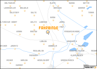
Fahrbinde (Mecklenburg-Vorpommern, Germany)Fahrbinde is a town in the Mecklenburg-Vorpommern region of Germany. An overview map of the region around Fahrbinde is displayed below.
regional and 3d topo map of Fahrbinde, Germany ::
Fahrbinde airports ::
The nearest airport is SZW - Schwerin Parchim, located 20.1 km east of Fahrbinde.
Other airports nearby include LBC - Luebeck Lubeck Blankensee (64.2 km north west), RLG - Laage (74.0 km north east), HAM - Hamburg (101.1 km west), XFW - Hamburg Finkenwerder (109.7 km west), Nearby towns ::
Lübesse (3.9km north) //
Ortkrug (3.9km north) //
Lüblow (3.9km south) //
Dreenkrögen (3.9km south) //
Goldenstädt (2.9km north east) //
Rastow (3.3km west) //
Mirow (5.7km north) //
Pulverhof (3.8km north west) //
Wöbbelin (5.7km south) //
Jamel (5.0km north east) //
Uelitz (5.0km north west) //
Neu Lüblow (7.7km south) //
Sülte (8.1km north west) //
[all distances 'as the bird flies' and approximate]  Places with similar names to Fahrbinde, Germany ::
// Feierabend (DE)
// Fray Benito (CU)
// Fierbinţi (RO)
// Varbandeh (IR)
// Ghar Bānda (PK)
// Farabandi (ML)
// Farba Nʼ Daw (GM)
// Ghowr Band (AF)
Disclaimer :: Information on this page comes without warranty of any kind |
||
|
Where is Fahrbinde? Elevation and coordinates ::
Latitude (lat): 53°27'0"N Longitude (lon): 11°29'0"E
Elevation (approx.): 39m (map arrows pan, magnifying glasses zoom) |
||
|
Visiting Fahrbinde? Hotel/Accommodation ::
Book a hotel in Fahrbinde Travel Guide ::
Buy a travel guide for Germany rental cars ::
car rental offers GPS waypoint ::
download a GPX waypoint (PoI) of Fahrbinde for your GPS receiver
|
||