|
search place name
|
||
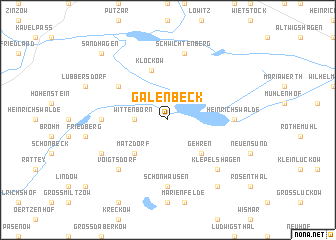
Galenbeck (Mecklenburg-Vorpommern, Germany)Galenbeck is a town in the Mecklenburg-Vorpommern region of Germany. An overview map of the region around Galenbeck is displayed below.
regional and 3d topo map of Galenbeck, Germany ::
Galenbeck airports ::
The nearest airport is SZZ - Szczechin Goleniow, located 79.7 km east of Galenbeck.
Other airports nearby include RLG - Laage (99.6 km west), TXL - Berlin Tegel (120.8 km south), THF - Berlin Tempelhof (128.8 km south), SZW - Schwerin Parchim (128.9 km west), Nearby towns ::
Wittenborn (2.2km west) //
Matzdorf (4.3km south west) //
Gehren (4.3km south east) //
Klockow (5.7km north) //
Kotelow (5.0km north west) //
Friedrichshof (4.4km west) //
Heinrichswalde (4.4km east) //
Schönhausen (7.4km south) //
Schwichtenberg (7.5km north) //
Voigtsdorf (6.5km south west) //
Klepelshagen (6.5km south east) //
Charlottenhof (5.8km south west) //
Schwarzensee (8.1km south east) //
Sandhagen (8.6km north west) //
[all distances 'as the bird flies' and approximate]  Places with similar names to Galenbeck, Germany ::
// Galenbeck (DE)
// Kallenbeck (DE)
// Kleinbocka (DE)
// Klein Buckow (DE)
// Kleinbuckow (DE)
// Kohlenbek (DE)
// Kolonia Boćki (PL)
// Kolonia Byki (PL)
// Glenboka (UA)
// Kolonbek (RU)
Disclaimer :: Information on this page comes without warranty of any kind |
||
|
Where is Galenbeck? Elevation and coordinates ::
Latitude (lat): 53°37'0"N Longitude (lon): 13°42'0"E
Elevation (approx.): 21m (map arrows pan, magnifying glasses zoom) |
||
|
Visiting Galenbeck? Hotel/Accommodation ::
Book a hotel in Galenbeck Travel Guide ::
Buy a travel guide for Germany rental cars ::
car rental offers GPS waypoint ::
download a GPX waypoint (PoI) of Galenbeck for your GPS receiver
|
||