|
search place name
|
||
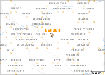
Geroda (Bayern, Germany)Geroda is a town in the Bayern region of Germany. An overview map of the region around Geroda is displayed below.
regional and 3d topo map of Geroda, Germany ::
Geroda airports ::
The nearest airport is ZNF - Hanau Aaf, located 68.2 km west of Geroda.
Other airports nearby include GHF - Giebelstadt Aaf (70.8 km south), FRA - Frankfurt Main (101.1 km west), ERF - Erfurt (107.7 km north east), NUE - Nuernberg Nurnberg (121.0 km south east), Nearby towns ::
Platz (2.2km south east) //
Schildeck (2.4km west) //
Schondra (3.0km south west) //
Oehrberg (3.9km south) //
Singenrain (3.9km south) //
Unterriedenberg (4.4km north west) //
Waldfenster (4.0km south east) //
Oberriedenberg (6.0km north west) //
Schönderling (5.1km south west) //
Riedenberg (5.1km north west) //
Mitgenfeld (4.7km west) //
Einraffshof (5.1km west) //
Oberbach (7.5km north) //
Eckartsroth (7.8km north) //
Katzenbach (6.0km south east) //
Lauter bei Bad Kissingen (6.0km south east) //
Hassenbach (8.2km south east) //
Schlimpfhof (8.8km south east) //
[all distances 'as the bird flies' and approximate]  Places with similar names to Geroda, Germany ::
Disclaimer :: Information on this page comes without warranty of any kind |
||
|
Where is Geroda? Elevation and coordinates ::
Latitude (lat): 50°17'0"N Longitude (lon): 9°54'0"E
Elevation (approx.): 483m (map arrows pan, magnifying glasses zoom) |
||
|
Visiting Geroda? Hotel/Accommodation ::
Book a hotel in Geroda Travel Guide ::
Buy a travel guide for Germany rental cars ::
car rental offers GPS waypoint ::
download a GPX waypoint (PoI) of Geroda for your GPS receiver
|
||