|
search place name
|
||
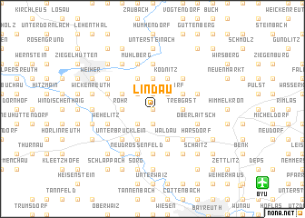
Lindau (Bayern, Germany)Lindau is a town in the Bayern region of Germany. An overview map of the region around Lindau is displayed below.
regional and 3d topo map of Lindau, Germany ::
Lindau airports ::
The nearest airport is BYU - Bayreuth, located 12.6 km south east of Lindau.
Other airports nearby include HOQ - Hof Plauen (34.6 km north east), NUE - Nuernberg Nurnberg (71.0 km south west), KLV - Karlovy Vary (101.1 km east), ERF - Erfurt (109.0 km north), Nearby towns ::
Spitzeichen (0.0km north) //
Listenberg (1.9km north) //
Siebenbrunn (1.9km south) //
Waizendorf (2.2km north east) //
Heinersreuth (2.2km north west) //
Schwingen (2.2km south west) //
Tauschthal (2.4km east) //
Eichholz (2.4km east) //
Trebgast (2.4km east) //
Ebersbach (3.7km north) //
Leuchau (2.4km west) //
Rohr (2.4km west) //
Feuln (3.0km north east) //
Ködnitz (3.9km north) //
See (3.9km north) //
Hauenreuth (3.9km north) //
Waldau (3.9km south) //
Tennach (3.0km north west) //
Brücklein (3.9km south) //
Hornungsreuth (3.9km south) //
Oberbrücklein (3.9km south) //
Oberlangenroth (4.4km north east) //
Unterlangenroth (4.4km north east) //
Unterlaitsch (4.4km south east) //
Unterbrücklein (4.4km south west) //
Hölle (5.6km south) //
Eberhardtsreuth (5.6km south) //
Fölschnitz (5.6km north) //
Pechgraben (5.7km south) //
[all distances 'as the bird flies' and approximate]  Places with similar names to Lindau, Germany ::
Disclaimer :: Information on this page comes without warranty of any kind |
||
|
Where is Lindau? Elevation and coordinates ::
Latitude (lat): 50°4'0"N Longitude (lon): 11°31'0"E
Elevation (approx.): 441m (map arrows pan, magnifying glasses zoom) |
||
|
Visiting Lindau? Hotel/Accommodation ::
Book a hotel in Lindau Travel Guide ::
Buy a travel guide for Germany rental cars ::
car rental offers GPS waypoint ::
download a GPX waypoint (PoI) of Lindau for your GPS receiver
|
||