|
search place name
|
||
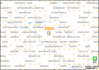
Rohr (Bayern, Germany)Rohr is a town in the Bayern region of Germany. An overview map of the region around Rohr is displayed below.
regional and 3d topo map of Rohr, Germany ::
Rohr airports ::
The nearest airport is BYU - Bayreuth, located 14.4 km south east of Rohr.
Other airports nearby include HOQ - Hof Plauen (36.3 km north east), NUE - Nuernberg Nurnberg (69.9 km south west), KLV - Karlovy Vary (103.5 km east), ERF - Erfurt (108.2 km north), Nearby towns ::
Leuchau (0.0km north) //
Tennach (1.9km north) //
Forstlahm (2.2km north west) //
Gelbe Weiden (2.2km north west) //
Heinersreuth (2.2km north east) //
Wehelitz (2.2km south west) //
Schwingen (2.2km south east) //
Lanzenreuth (2.4km west) //
Gössmannsreuth (2.4km west) //
Unterbrücklein (3.7km south) //
Lindau (2.4km east) //
Spitzeichen (2.4km east) //
Wickenreuth (3.0km north west) //
Mangersreuth (3.0km north west) //
Plassenburg (3.9km north) //
Dreschen (3.0km south west) //
Buch am Sand (3.0km south west) //
Hauenreuth (3.9km north) //
Listenberg (3.0km north east) //
Brücklein (3.9km south) //
Hornungsreuth (3.9km south) //
Oberbrücklein (3.9km south) //
Siebenbrunn (3.0km south east) //
Weiher (4.4km north west) //
Kulmbach (4.4km north west) //
Langenstadt (4.4km south west) //
Ebersbach (4.4km north east) //
Unterobsang (5.6km south) //
Unterzettlitz (3.6km west) //
[all distances 'as the bird flies' and approximate]  Places with similar names to Rohr, Germany ::
Disclaimer :: Information on this page comes without warranty of any kind |
||
|
Where is Rohr? Elevation and coordinates ::
Latitude (lat): 50°4'0"N Longitude (lon): 11°29'0"E
Elevation (approx.): 360m (map arrows pan, magnifying glasses zoom) |
||
|
Visiting Rohr? Hotel/Accommodation ::
Book a hotel in Rohr Travel Guide ::
Buy a travel guide for Germany rental cars ::
car rental offers GPS waypoint ::
download a GPX waypoint (PoI) of Rohr for your GPS receiver
|
||