|
search place name
|
||
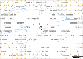
Sankt Johann (Bayern, Germany)Sankt Johann is a town in the Bayern region of Germany. An overview map of the region around Sankt Johann is displayed below.
regional and 3d topo map of Sankt Johann, Germany ::
Sankt Johann airports ::
The nearest airport is SZG - Salzburg, located 43.8 km south of Sankt Johann.
Other airports nearby include MUC - Munich Munchen (79.3 km west), LNZ - Linz (Horsching) (102.2 km east), OBF - Oberpfaffenhofen (114.6 km west), FEL - Fuerstenfeldbruck Furstenfeldbruck (115.3 km west), Nearby towns ::
Hiebel (1.2km east) //
Burghausen (1.2km east) //
Badhöring (1.9km north) //
Unghausen (1.2km west) //
Lindach (1.2km west) //
Heilig Kreuz (1.9km south) //
Wanghausen (1.9km south) //
Lengthal (2.2km north west) //
Ach (2.2km south east) //
Oberkriebach (2.2km south east) //
Fuchshausen (2.2km south west) //
Laimgruben (2.2km south west) //
Bergham (2.2km south west) //
Neuburghausen (2.5km east) //
Brunn (2.5km west) //
Holzfeld (3.1km north east) //
Duttendorf (3.1km south east) //
Unterkriebach (3.1km south east) //
Mehring (3.1km north west) //
Kälbermoos (3.9km south) //
Marienberg (3.1km south west) //
Holzgassen (3.9km south) //
Scheuerhof (3.9km south) //
Kemerting (4.5km north east) //
Unteremmerting (4.5km north west) //
Hohenwart (4.5km north west) //
Geretsdorf (4.5km south east) //
Unterhadermark (4.5km south west) //
Oberhadermark (4.5km south west) //
[all distances 'as the bird flies' and approximate]  Places with similar names to Sankt Johann, Germany ::
// Sankt Johann (CH)
// Sankt Johann (AT)
// Sankt Johann (AT)
// Sankt Johann (AT)
// Sankt Johann (AT)
// Sankt Johann (AT)
// Sankt Johann (DE)
// Sankt Johann (DE)
// Sankt Johann (DE)
// Sankt Johann (DE)
Disclaimer :: Information on this page comes without warranty of any kind |
||
|
Where is Sankt Johann? Elevation and coordinates ::
Latitude (lat): 48°10'0"N Longitude (lon): 12°49'0"E
Elevation (approx.): 426m (map arrows pan, magnifying glasses zoom) |
||
|
Visiting Sankt Johann? Hotel/Accommodation ::
Book a hotel in Sankt Johann Travel Guide ::
Buy a travel guide for Germany rental cars ::
car rental offers GPS waypoint ::
download a GPX waypoint (PoI) of Sankt Johann for your GPS receiver
|
||