|
search place name
|
||
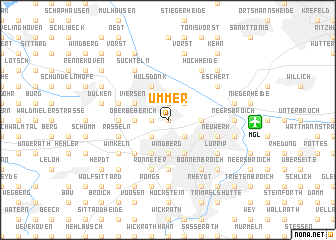
Ummer (Nordrhein-Westfalen, Germany)Ummer is a town in the Nordrhein-Westfalen region of Germany. An overview map of the region around Ummer is displayed below.
regional and 3d topo map of Ummer, Germany ::
Ummer airports ::
The nearest airport is MGL - Moenchengladbach Monchengladbach, located 6.1 km east of Ummer.
Other airports nearby include DUS - Duesseldorf Dusseldorf (25.2 km east), GKE - Geilenkirchen (40.1 km south west), ESS - Essen Mulheim (40.9 km north east), MST - Maastricht (57.7 km south west), Nearby towns ::
Helenabrunn (NaNkm north) //
Heimer (NaNkm north) //
Ompert (1.2km west) //
Unterbeberich (1.2km west) //
Robend (1.9km north) //
Hamm (1.9km north) //
Eicken (2.2km south east) //
Großheide (2.2km south west) //
Bötzlöh (2.2km south west) //
Düpp (2.2km north east) //
Windberg (3.7km south) //
Fuchshütte (2.3km east) //
Donk (2.3km east) //
Brasselstraße (2.3km west) //
Oberbeberich (2.3km west) //
Mönchengladbach (3.9km south) //
Hoven (3.0km south east) //
Dünn (3.0km south east) //
Hamern (3.9km south) //
Viersen (3.0km north west) //
Hülsdonk (3.9km north) //
Venn (4.4km south west) //
Beltinghoven (4.4km south west) //
Dahl (5.6km south) //
Bockert (3.5km west) //
Damm (3.9km south east) //
Neuwerk (3.9km south east) //
Engelbleck (3.9km south east) //
Rasseln (3.9km south west) //
[all distances 'as the bird flies' and approximate]  Places with similar names to Ummer, Germany ::
Disclaimer :: Information on this page comes without warranty of any kind |
||
|
Where is Ummer? Elevation and coordinates ::
Latitude (lat): 51°14'0"N Longitude (lon): 6°25'0"E
Elevation (approx.): 43m (map arrows pan, magnifying glasses zoom) |
||
|
Visiting Ummer? Hotel/Accommodation ::
Book a hotel in Ummer Travel Guide ::
Buy a travel guide for Germany rental cars ::
car rental offers GPS waypoint ::
download a GPX waypoint (PoI) of Ummer for your GPS receiver
|
||