|
search place name
|
||
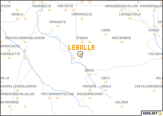
Le Bolle (Italy)Le Bolle is a town in Italy. An overview map of the region around Le Bolle is displayed below.
regional and 3d topo map of Le Bolle, Italy ::
Le Bolle airports ::
The nearest airport is FLR - Firenze, located 22.8 km north of Le Bolle.
Other airports nearby include SAY - Siena Ampugnano (40.2 km south), PSA - Pisa (73.6 km west), FRL - Forli (89.2 km north east), GRS - Grosseto (97.0 km south), Nearby towns ::
Vicchiomaggio (1.3km west) //
Chiocchio (2.3km north east) //
Strada (3.7km north) //
Mugnana (3.9km north) //
Greve (3.9km south) //
Panzano (7.5km south) //
Linari (6.9km north east) //
Corti (6.9km south east) //
Impruneta (8.4km north west) //
Lamole (8.4km south east) //
[all distances 'as the bird flies' and approximate] 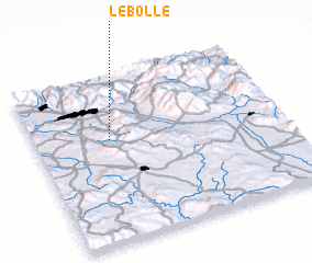 Places with similar names to Le Bolle, Italy ::
Disclaimer :: Information on this page comes without warranty of any kind |
||
|
Where is Le Bolle? Elevation and coordinates ::
Latitude (lat): 43°37'0"N Longitude (lon): 11°18'0"E
Elevation (approx.): 260m (map arrows pan, magnifying glasses zoom) |
||
|
Visiting Le Bolle? Hotel/Accommodation ::
Book a hotel in Le Bolle Travel Guide ::
Buy a travel guide for Italy rental cars ::
car rental offers GPS waypoint ::
download a GPX waypoint (PoI) of Le Bolle for your GPS receiver
|
||