|
search place name
|
||
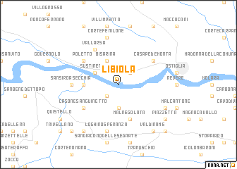
Libiola (Italy)Libiola is a town in Italy. An overview map of the region around Libiola is displayed below.
regional and 3d topo map of Libiola, Italy ::
Libiola airports ::
The nearest airport is VRN - Villafranca, located 40.5 km north of Libiola.
Other airports nearby include BLQ - Bologna (60.2 km south), PMF - Parma (64.5 km south west), VIC - Vicenza (69.3 km north east), VBS - Montichiari (70.5 km north west), Nearby towns ::
Quingentole (2.3km south west) //
Corte Torriana (2.3km north east) //
Cascina Fienili (3.7km south) //
Sustinente (3.2km north west) //
Bisarina (3.9km north) //
Santa Lucia (3.9km west) //
Malregolata (5.7km south) //
Casone Sanguinetto (5.4km south west) //
Casa Pedemonta (5.4km north east) //
Poletto (5.4km north west) //
Vallarsa (6.1km north west) //
San Siro a Secchia (5.2km west) //
Loghino Speranza (7.5km south) //
Corte Fenilone (7.5km north) //
Ghisione (6.4km south east) //
Piazzetta (7.6km south east) //
Valdirame (8.4km south east) //
San Rocco (8.4km south west) //
Poggio Rusco (9.1km south east) //
La Cavriana (9.1km south west) //
[all distances 'as the bird flies' and approximate]  Places with similar names to Libiola, Italy ::
Disclaimer :: Information on this page comes without warranty of any kind |
||
|
Where is Libiola? Elevation and coordinates ::
Latitude (lat): 45°3'0"N Longitude (lon): 11°3'0"E
Elevation (approx.): 14m (map arrows pan, magnifying glasses zoom) |
||
|
Visiting Libiola? Hotel/Accommodation ::
Book a hotel in Libiola Travel Guide ::
Buy a travel guide for Italy rental cars ::
car rental offers GPS waypoint ::
download a GPX waypoint (PoI) of Libiola for your GPS receiver
|
||