|
search place name
|
||
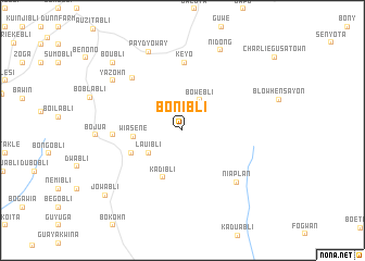
Bonibli (Grand Bassa, Liberia)Bonibli is a town in the Grand Bassa region of Liberia. An overview map of the region around Bonibli is displayed below.
regional and 3d topo map of Bonibli, Liberia ::
Bonibli airports ::
The nearest airport is ROB - Monrovia Roberts Intl, located 99.1 km west of Bonibli.
Other airports nearby include MLW - Monrovia Spriggs Payne (142.7 km west), MJC - Man (233.9 km north east), Nearby towns ::
Bowebli (3.6km north east) //
Lauibli (4.1km south west) //
Wiasene (5.0km west) //
Kadibli (5.2km south) //
Daunbinibli (5.7km south west) //
Keyo (7.0km north) //
Gejo (7.1km west) //
Wrayua (7.5km north west) //
Niaplan (7.7km south east) //
Yazohn (8.7km north west) //
Paydyoway (8.8km north west) //
Nidong (9.1km north east) //
Boubli (9.9km north west) //
Jowabli (10.3km south west) //
[all distances 'as the bird flies' and approximate] 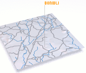 Places with similar names to Bonibli, Liberia ::
// Banbala (CM)
// Bonnie Bell (US)
// Bona Bella (US)
// Ban Ao Bo Le (TH)
// Ban Ao Bo Le (TH)
// Ban Ba La (TH)
// Ban Bala (TH)
// Ban Bala (TH)
// Ban Balae (TH)
// Ban Ba Lo (TH)
Disclaimer :: Information on this page comes without warranty of any kind |
||
|
Where is Bonibli? Elevation and coordinates ::
Latitude (lat): 6°18'15"N Longitude (lon): 9°28'9"W
Elevation (approx.): 217m (map arrows pan, magnifying glasses zoom) |
||
|
Visiting Bonibli? Hotel/Accommodation ::
Book a hotel in Bonibli Travel Guide ::
Buy a travel guide for Liberia rental cars ::
car rental offers GPS waypoint ::
download a GPX waypoint (PoI) of Bonibli for your GPS receiver
|
||