|
search place name
|
||
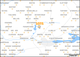
Dons (Vejle, Denmark)Dons is a town in the Vejle region of Denmark. An overview map of the region around Dons is displayed below.
regional and 3d topo map of Dons, Denmark ::
Dons airports ::
The nearest airport is BLL - Billund, located 28.3 km north west of Dons.
Other airports nearby include SKS - Skrydstrup (38.0 km south), ODE - Odense (56.2 km east), EBJ - Esbjerg (56.7 km west), SGD - Soenderborg Sonderborg (68.7 km south), Nearby towns ::
Almind Hede (1.0km east) //
Rådvad (3.7km south) //
Bramdrupdam (3.9km south) //
Vester Nebel (2.8km north west) //
Ågård (3.9km north) //
Kolding (4.3km south east) //
Bramdrup (4.3km south east) //
Ferup Nyvang (3.1km west) //
Øster Starup (5.6km north) //
Stubdrup (3.7km south west) //
Harte (5.7km south) //
Lilballe (3.7km south east) //
Almind (3.7km north east) //
Gravens (5.7km north) //
Påby (5.9km south) //
Balle (4.9km north west) //
Viuf (4.9km north east) //
Seest (7.4km south) //
Ferup (4.6km south west) //
Brakker (6.4km north west) //
Hesselballe (7.7km north) //
Fredsted (7.7km north) //
Ejstrup (7.0km south west) //
Vrannerup (7.0km south west) //
Nyby Strandhuse (7.0km south east) //
Borlev (8.1km north west) //
Tved (8.5km south east) //
[all distances 'as the bird flies' and approximate]  Places with similar names to Dons, Denmark ::
Disclaimer :: Information on this page comes without warranty of any kind |
||
|
Where is Dons? Elevation and coordinates ::
Latitude (lat): 55°33'0"N Longitude (lon): 9°27'0"E
Elevation (approx.): 53m (map arrows pan, magnifying glasses zoom) |
||
|
Visiting Dons? Hotel/Accommodation ::
Book a hotel in Dons Travel Guide ::
Buy a travel guide for Denmark rental cars ::
car rental offers GPS waypoint ::
download a GPX waypoint (PoI) of Dons for your GPS receiver
|
||