|
search place name
|
||
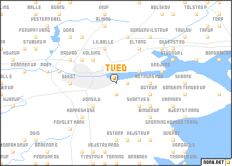
Tved (Vejle, Denmark)Tved is a town in the Vejle region of Denmark. An overview map of the region around Tved is displayed below.
regional and 3d topo map of Tved, Denmark ::
Tved airports ::
The nearest airport is SKS - Skrydstrup, located 32.9 km south west of Tved.
Other airports nearby include BLL - Billund (36.7 km north west), ODE - Odense (51.5 km east), SGD - Soenderborg Sonderborg (60.4 km south), EBJ - Esbjerg (61.1 km west), Nearby towns ::
Rebæk (1.1km east) //
Dalby (1.9km south) //
Nyby Strandhuse (1.9km north) //
Nørre Bjert (2.8km north east) //
Skartved (4.3km south east) //
Vonsild (4.3km south west) //
Kolding (4.3km north west) //
Bramdrup (4.3km north west) //
Agtrupskov (3.2km east) //
Agtrup (3.7km south east) //
Lilballe (5.7km north) //
Sønder Bjert (4.9km south east) //
Eltang (5.9km north) //
Bramdrupdam (4.9km north west) //
Seest (4.2km west) //
Drejens (4.6km north east) //
Møsvrå (7.5km north) //
Hoppeshuse (6.4km south west) //
Binderup (6.4km south east) //
Rådvad (5.6km north west) //
Gudsø (7.0km north east) //
Sønder Vilstrup (8.1km north east) //
Almind Hede (8.1km north west) //
Fovslet Mark (8.5km south west) //
Dons (8.5km north west) //
[all distances 'as the bird flies' and approximate] 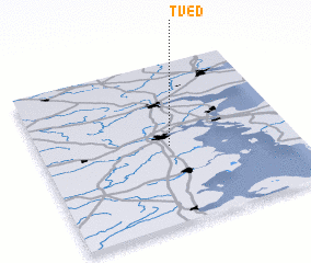 Places with similar names to Tved, Denmark ::
Disclaimer :: Information on this page comes without warranty of any kind |
||
|
Where is Tved? Elevation and coordinates ::
Latitude (lat): 55°29'0"N Longitude (lon): 9°31'0"E
Elevation (approx.): 10m (map arrows pan, magnifying glasses zoom) |
||
|
Visiting Tved? Hotel/Accommodation ::
Book a hotel in Tved Travel Guide ::
Buy a travel guide for Denmark rental cars ::
car rental offers GPS waypoint ::
download a GPX waypoint (PoI) of Tved for your GPS receiver
|
||