|
search place name
|
||
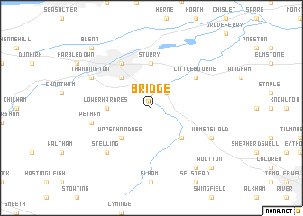
Bridge (United Kingdom)Bridge is a town in United Kingdom. An overview map of the region around Bridge is displayed below.
regional and 3d topo map of Bridge, United Kingdom ::
Bridge airports ::
The nearest airport is MSE - Manston, located 20.1 km north east of Bridge.
Other airports nearby include LYX - Lydd (33.3 km south), SEN - Southend (47.7 km north west), CQF - Calais Dunkerque (66.0 km south east), BQH - Biggin Hill (76.4 km west), Nearby towns ::
Bekesbourne (2.2km north east) //
Kingston (4.4km south east) //
Upper Hardres (4.4km south west) //
Canterbury (4.4km north west) //
Lower Hardres (3.5km west) //
Sturry (5.6km north) //
Fordwich (5.6km north) //
Littlebourne (5.1km north east) //
Hackington (6.0km north west) //
Petham (5.0km west) //
Stelling (6.6km south west) //
Womenswold (5.9km south east) //
Thannington (5.9km north west) //
Denton (8.2km south east) //
Wootton (8.7km south east) //
Blean (8.7km north west) //
[all distances 'as the bird flies' and approximate]  Places with similar names to Bridge, United Kingdom ::
Disclaimer :: Information on this page comes without warranty of any kind |
||
|
Where is Bridge? Elevation and coordinates ::
Latitude (lat): 51°14'0"N Longitude (lon): 1°7'0"E
Elevation (approx.): 58m (map arrows pan, magnifying glasses zoom) |
||
|
Visiting Bridge? Hotel/Accommodation ::
Book a hotel in Bridge Travel Guide ::
rental cars ::
car rental offers GPS waypoint ::
download a GPX waypoint (PoI) of Bridge for your GPS receiver
|
||