|
search place name
|
||
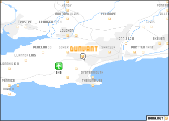
Dunvant (United Kingdom)Dunvant is a town in United Kingdom. An overview map of the region around Dunvant is displayed below.
regional and 3d topo map of Dunvant, United Kingdom ::
Dunvant airports ::
The nearest airport is SWS - Swansea, located 3.8 km west of Dunvant.
Other airports nearby include CWL - Cardiff (52.8 km south east), BRS - Bristol (93.8 km east), FZO - Bristol Filton (99.5 km east), EXT - Exeter (106.8 km south east), Nearby towns ::
Killay (2.2km south west) //
Gowerton (3.0km north west) //
Oystermouth (3.9km south) //
Bishopston (4.4km south west) //
Gorseinon (5.7km north) //
Swansea (3.9km north east) //
The Mumbles (5.7km south) //
Loughor (6.0km north) //
Llangennech (8.7km north west) //
Bynea (8.7km north west) //
[all distances 'as the bird flies' and approximate]  Places with similar names to Dunvant, United Kingdom ::
// Dunavant (US)
// Dunavant (US)
// Dunavant (US)
// Danéfandou (NE)
// Tīneh Vand (IR)
// Den Veind (BE)
Disclaimer :: Information on this page comes without warranty of any kind |
||
|
Where is Dunvant? Elevation and coordinates ::
Latitude (lat): 51°37'0"N Longitude (lon): 4°1'0"W
Elevation (approx.): 72m (map arrows pan, magnifying glasses zoom) |
||
|
Visiting Dunvant? Hotel/Accommodation ::
Book a hotel in Dunvant Travel Guide ::
rental cars ::
car rental offers GPS waypoint ::
download a GPX waypoint (PoI) of Dunvant for your GPS receiver
|
||