|
search place name
|
||
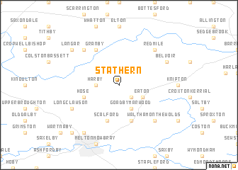
Stathern (United Kingdom)Stathern is a town in United Kingdom. An overview map of the region around Stathern is displayed below.
regional and 3d topo map of Stathern, United Kingdom ::
Stathern airports ::
The nearest airport is EMA - Nottingham East Midlands, located 32.3 km west of Stathern.
Other airports nearby include WTN - Waddington (41.4 km north east), QCY - Coningsby (53.3 km north east), CVT - Coventry (68.4 km south west), BHX - Birmingham (75.1 km south west), Nearby towns ::
Eastwell (2.2km south east) //
Harby (2.2km west) //
Eaton (2.9km south east) //
Goadby Marwood (3.9km south) //
Hose (3.8km south west) //
Chadwell (5.7km south) //
Scalford (5.7km south) //
Granby (6.0km north) //
Redmile (6.5km north east) //
Barnstone (6.5km north west) //
Waltham on the Wolds (6.5km south east) //
Belvoir (5.8km north east) //
Long Clawson (5.8km south west) //
Langar (7.1km north west) //
Holwell (8.1km south west) //
Ab Kettleby (8.7km south west) //
[all distances 'as the bird flies' and approximate]  Places with similar names to Stathern, United Kingdom :: Disclaimer :: Information on this page comes without warranty of any kind |
||
|
Where is Stathern? Elevation and coordinates ::
Latitude (lat): 52°51'0"N Longitude (lon): 0°51'0"W
Elevation (approx.): 152m (map arrows pan, magnifying glasses zoom) |
||
|
Visiting Stathern? Hotel/Accommodation ::
Book a hotel in Stathern Travel Guide ::
rental cars ::
car rental offers GPS waypoint ::
download a GPX waypoint (PoI) of Stathern for your GPS receiver
|
||