|
search place name
|
||
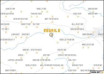
Redmile (United Kingdom)Redmile is a town in United Kingdom. An overview map of the region around Redmile is displayed below.
regional and 3d topo map of Redmile, United Kingdom ::
Redmile airports ::
The nearest airport is WTN - Waddington, located 34.9 km north east of Redmile.
Other airports nearby include EMA - Nottingham East Midlands (36.4 km west), QCY - Coningsby (47.7 km north east), CVT - Coventry (74.8 km south west), HUY - Humberside (80.8 km north), Nearby towns ::
Belvoir (2.2km south east) //
Bottesford (5.6km north) //
Woolsthorpe (3.8km south east) //
Knipton (6.0km south) //
Elton (5.0km north west) //
Staunton in the Vale (7.4km north) //
Eaton (7.5km south) //
Stathern (6.5km south west) //
Eastwell (7.7km south) //
Thoroton (8.1km north west) //
Croxton Kerrial (8.1km south east) //
Long Bennington (8.1km north east) //
Orston (7.1km north west) //
Hawksworth (8.7km north west) //
[all distances 'as the bird flies' and approximate]  Places with similar names to Redmile, United Kingdom ::
// Radmühl (DE)
// Radmühl (DE)
// Rio de Mel (PT)
// Rio de Mel (PT)
// Ruda Mała (PL)
// Radomile (BA)
// Radumili (BA)
// Retamal (ES)
// Retamal (ES)
// Red Mill (US)
Disclaimer :: Information on this page comes without warranty of any kind |
||
|
Where is Redmile? Elevation and coordinates ::
Latitude (lat): 52°54'0"N Longitude (lon): 0°48'0"W
Elevation (approx.): 62m (map arrows pan, magnifying glasses zoom) |
||
|
Visiting Redmile? Hotel/Accommodation ::
Book a hotel in Redmile Travel Guide ::
rental cars ::
car rental offers GPS waypoint ::
download a GPX waypoint (PoI) of Redmile for your GPS receiver
|
||