|
search place name
|
||
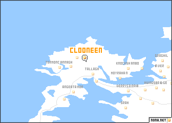
Clooneen (Maigh Eo, Ireland)Clooneen is a town in the Maigh Eo region of Ireland. An overview map of the region around Clooneen is displayed below.
regional and 3d topo map of Clooneen, Ireland ::
Clooneen airports ::
The nearest airport is NOC - Connaught, located 87.4 km south east of Clooneen.
Other airports nearby include SXL - Sligo (92.0 km east), GWY - Galway (128.3 km south east), SNN - Shannon (188.1 km south east), Nearby towns ::
Aghadoon (1.5km north west) //
Tallagh (2.8km south) //
Glenlara (2.7km north east) //
Corclogh (2.2km south west) //
Béal an Mhuirthead (4.5km south) //
Belmullet (4.5km south) //
Termoncarragh (3.6km west) //
An Geata Mór (6.8km south) //
Moyrahan (5.7km south east) //
Drumreagh (8.7km south) //
[all distances 'as the bird flies' and approximate]  Places with similar names to Clooneen, Ireland ::
// Kalinino (AZ)
// Calaanan (PH)
// Calaanan (PH)
// Calañan (PH)
// Calanan (PH)
// Calanian (PH)
// Calao-anan (PH)
// Calauan-on (PH)
// Calinauan (PH)
// Colinauan (PH)
Disclaimer :: Information on this page comes without warranty of any kind |
||
|
Where is Clooneen? Elevation and coordinates ::
Latitude (lat): 54°15'48"N Longitude (lon): 10°0'42"W
Elevation (approx.): 14m (map arrows pan, magnifying glasses zoom) |
||
|
Visiting Clooneen? Hotel/Accommodation ::
Book a hotel in Clooneen Travel Guide ::
Buy a travel guide for Ireland rental cars ::
car rental offers GPS waypoint ::
download a GPX waypoint (PoI) of Clooneen for your GPS receiver
|
||