|
search place name
|
||
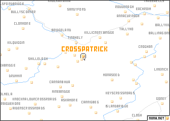
Crosspatrick (Cill Mhantáin, Ireland)Crosspatrick is a town in the Cill Mhantáin region of Ireland. An overview map of the region around Crosspatrick is displayed below.
regional and 3d topo map of Crosspatrick, Ireland ::
Crosspatrick airports ::
The nearest airport is DUB - Dublin, located 74.5 km north of Crosspatrick.
Other airports nearby include WAT - Waterford (77.3 km south west), IOM - Isle Of Man (190.6 km north east), ENK - Enniskillen St Angelo (199.1 km north west), BHD - Belfast City (210.2 km north), Nearby towns ::
Stonybatter (0.5km north west) //
Coolboy (1.0km west) //
Fairwood (1.8km north west) //
Kilcommon Bridge (3.0km north) //
Tinahely (4.2km north) //
Tigh na hÉille (4.2km north) //
Greenhall Bridge (3.2km north west) //
Coolalug Bridge (4.8km north east) //
Killicreny Bridge (5.4km north) //
Ballyellis Cross Roads (5.7km south) //
Coolattin (3.9km west) //
Monaseed (5.7km south east) //
Bridgeland (6.5km north west) //
Carn an Bhua (6.7km south west) //
Carnew (6.7km south west) //
Mine Bridge (8.5km south) //
Keys Cross Roads (9.6km south east) //
[all distances 'as the bird flies' and approximate]  Places with similar names to Crosspatrick, Ireland ::
// Crosspatrick (IE)
Disclaimer :: Information on this page comes without warranty of any kind |
||
|
Where is Crosspatrick? Elevation and coordinates ::
Latitude (lat): 52°45'38"N Longitude (lon): 6°26'45"W
Elevation (approx.): 107m (map arrows pan, magnifying glasses zoom) |
||
|
Visiting Crosspatrick? Hotel/Accommodation ::
Book a hotel in Crosspatrick Travel Guide ::
Buy a travel guide for Ireland rental cars ::
car rental offers GPS waypoint ::
download a GPX waypoint (PoI) of Crosspatrick for your GPS receiver
|
||