|
search place name
|
||
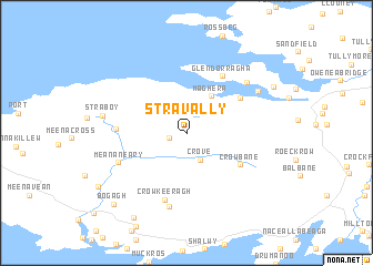
Stravally (Donegal, Ireland)Stravally is a town in the Donegal region of Ireland. An overview map of the region around Stravally is displayed below.
regional and 3d topo map of Stravally, Ireland ::
Stravally airports ::
The nearest airport is SXL - Sligo, located 50.1 km south of Stravally.
Other airports nearby include ENK - Enniskillen St Angelo (68.7 km south east), NOC - Connaught (92.9 km south), LDY - Londonderry Eglinton (95.6 km east), GWY - Galway (161.2 km south), Nearby towns ::
Lergynasearhagh (1.2km south west) //
Crove (2.7km south) //
Maghera (3.9km north) //
Crowbane (4.5km south east) //
Laconnell (4.6km north east) //
Glendorragha (6.1km north) //
Stranagartan (4.1km west) //
Crowkeeragh (6.8km south) //
Meananeary (5.0km south west) //
Meenychanon (7.6km south) //
Cloghboy (6.2km north east) //
Newtownburke (5.9km north east) //
Straboy (5.1km west) //
Crannogeboy (6.8km north east) //
Kilcasey (9.0km south) //
Bogagh (8.3km south west) //
Straleel (7.5km south west) //
[all distances 'as the bird flies' and approximate] 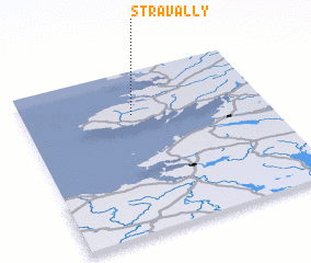 Places with similar names to Stravally, Ireland ::
// Cedarville (US)
// Star Valley (US)
// Cedarville (US)
// Seedörfl (AT)
// Cedarville (US)
// Cedar Valley (US)
// Cedar Valley (US)
// Strevell (US)
// Cedarville (US)
// Cedar Valley (US)
Disclaimer :: Information on this page comes without warranty of any kind |
||
|
Where is Stravally? Elevation and coordinates ::
Latitude (lat): 54°43'46"N Longitude (lon): 8°32'52"W
Elevation (approx.): 134m (map arrows pan, magnifying glasses zoom) |
||
|
Visiting Stravally? Hotel/Accommodation ::
Book a hotel in Stravally Travel Guide ::
Buy a travel guide for Ireland rental cars ::
car rental offers GPS waypoint ::
download a GPX waypoint (PoI) of Stravally for your GPS receiver
|
||