|
search place name
|
||
Dragići (Croatia)Dragići is a town in Croatia. An overview map of the region around Dragići is displayed below.
regional and 3d topo map of Dragići, Croatia ::

Dragići airports ::
The nearest airport is RJK - Rijeka, located 73.3 km west of Dragići.
Other airports nearby include ZAG - Zagreb (97.3 km north east), ZAD - Zadar (97.9 km south), PUY - Pula (120.4 km west), POW - Portoroz (153.4 km west), Nearby towns ::
Kneževići (0.6km south) //
Momčilovići (0.6km north east) //
Zavođe (0.7km west) //
Lička Jesenica (1.0km north) //
Vukelić Poljana (1.1km south east) //
Čikare (1.1km west) //
Potkapela (1.8km north west) //
Borik (1.6km east) //
Varoš (2.2km east) //
Lučića (2.5km south east) //
Tuk (2.4km east) //
Vuković Kapela (3.4km south east) //
Saborsko (2.8km east) //
Vrcelji (3.5km north west) //
Begovac Plaščanski (3.9km north west) //
Mala Kapela (3.7km west) //
Funtana (4.7km east) //
Ravni Lug (5.7km south east) //
Blata (6.2km north west) //
Živica (6.0km south west) //
Panjići (5.4km east) //
Jezero (7.8km north) //
Plavča-Draga (8.2km north) //
Donje Biljevina (6.3km east) //
Komadine (8.9km north west) //
Brezovac (9.4km south west) //
[all distances 'as the bird flies' and approximate] 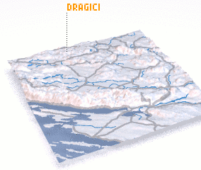 Places with similar names to Dragići, Croatia ::
Disclaimer :: Information on this page comes without warranty of any kind |
||
|
Where is Dragići? Elevation and coordinates ::
Latitude (lat): 44°59'11"N Longitude (lon): 15°26'33"E
Elevation (approx.): 504m (map arrows pan, magnifying glasses zoom) |
||
|
Visiting Dragići? Hotel/Accommodation ::
Book a hotel in Dragići Travel Guide ::
Buy a travel guide for Croatia rental cars ::
car rental offers GPS waypoint ::
download a GPX waypoint (PoI) of Dragići for your GPS receiver
|
||