|
search place name
|
||
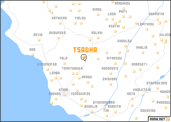
Tsadha (Cyprus)Tsadha is a town in Cyprus. An overview map of the region around Tsadha is displayed below.
regional and 3d topo map of Tsadha, Cyprus ::
Tsadha airports ::
The nearest airport is PFO - Paphos Pafos Intl, located 13.7 km south of Tsadha.
Other airports nearby include AKT - Akrotiri (54.6 km south east), LCA - Larnaca (105.2 km east), Nearby towns ::
Kallepia (2.3km east) //
Kili (2.8km north west) //
Mesoyi (3.2km south west) //
Trimithousa (3.6km south west) //
Mesa Khorio (3.9km south) //
Armou (4.6km south) //
Tala (3.8km west) //
Stroumbi (4.7km north) //
Letimbou (4.2km north east) //
Marathounda (5.7km south) //
Polemi (5.6km north east) //
Anavargos (5.6km south west) //
Moronero (5.3km south east) //
Pitargou (5.3km east) //
Emba (5.9km south west) //
Konia (6.7km south) //
Lemba (6.5km south west) //
Episkopi (6.8km south east) //
Kourtaka (6.4km east) //
Akoursos (7.1km north west) //
Yeroskipos (8.4km south) //
Yiolou (8.4km north) //
Khlorakas (7.4km south west) //
Kissonerga (7.1km west) //
Theletra (8.6km north) //
Ktima (8.3km south west) //
Ayia Marinoudha (8.8km south) //
Kato Panayia (7.2km east) //
Psathi (8.4km north east) //
[all distances 'as the bird flies' and approximate]  Places with similar names to Tsadha, Cyprus ::
// Tsutuho (IN)
Disclaimer :: Information on this page comes without warranty of any kind |
||
|
Where is Tsadha? Elevation and coordinates ::
Latitude (lat): 34°50'30"N Longitude (lon): 32°28'30"E
Elevation (approx.): 612m (map arrows pan, magnifying glasses zoom) |
||
|
Visiting Tsadha? Hotel/Accommodation ::
Book a hotel in Tsadha Travel Guide ::
Buy a travel guide for Cyprus rental cars ::
car rental offers GPS waypoint ::
download a GPX waypoint (PoI) of Tsadha for your GPS receiver
|
||