|
search place name
|
||
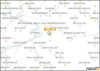
Achen (Lorraine, France)Achen is a town in the Lorraine region of France. An overview map of the region around Achen is displayed below.
regional and 3d topo map of Achen, France ::
Achen airports ::
The nearest airport is SCN - Saarbruecken Saarbrucken, located 19.1 km north of Achen.
Other airports nearby include RMS - Ramstein Ab (52.7 km north east), SXB - Strassbourg Entzheim (65.6 km south east), ETZ - Metz Nancy Lorraine (68.6 km west), MZM - Metz Frescaty (76.9 km west), Nearby towns ::
Etting (1.9km south) //
Woelfling-lès-Sarreguemines (3.7km north) //
Wiesviller (3.9km north) //
Gros-Réderching (3.1km north east) //
Kalhausen (4.4km south west) //
Schmittviller (5.6km south) //
Wittring (3.6km west) //
Bliesbruck (7.4km north) //
Bining (5.2km east) //
Dehlingen (7.5km south) //
Blies-Ébersing (7.8km north) //
Rahling (7.8km south) //
Obergailbach (7.8km north) //
Oermingen (7.4km south west) //
[all distances 'as the bird flies' and approximate] 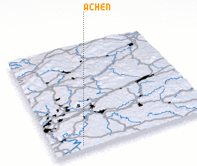 Places with similar names to Achen, France ::
Disclaimer :: Information on this page comes without warranty of any kind |
||
|
Where is Achen? Elevation and coordinates ::
Latitude (lat): 49°3'0"N Longitude (lon): 7°11'0"E
Elevation (approx.): 258m (map arrows pan, magnifying glasses zoom) |
||
|
Visiting Achen? Hotel/Accommodation ::
Book a hotel in Achen Travel Guide ::
Buy a travel guide for France rental cars ::
car rental offers GPS waypoint ::
download a GPX waypoint (PoI) of Achen for your GPS receiver
|
||