|
search place name
|
||
Angoville (Basse-Normandie, France)Angoville is a town in the Basse-Normandie region of France. An overview map of the region around Angoville is displayed below.
regional and 3d topo map of Angoville, France ::

Angoville airports ::
The nearest airport is CFR - Caen Carpiquet, located 27.1 km north of Angoville.
Other airports nearby include DOL - Deauville St Gatien (62.0 km north east), LEH - Le Havre Octeville (75.1 km north east), LVA - Laval Entrammes (103.8 km south), CER - Cherbourg Maupertus (112.3 km north west), Nearby towns ::
Bonnoeil (2.2km south east) //
Pierrefitte-en-Cinglais (3.7km south) //
Acqueville (3.9km north) //
Meslay (3.9km north) //
Donnay (3.1km north west) //
Tréprel (4.4km south east) //
La Pommeraye (4.4km south west) //
Cossesseville (4.4km south west) //
Saint-Omer (4.1km south west) //
Cesny-Bois-Halbout (5.7km north) //
Combray (4.1km north west) //
Martainville (4.1km north east) //
Ouilly-le-Basset (5.7km south) //
Pierrepont (5.2km south east) //
Placy (6.1km north west) //
Tournebu (5.2km north east) //
Fresney-le-Vieux (7.4km north) //
Saint-Germain-Langot (5.2km east) //
Moulines (6.7km north east) //
Saint-Marc-dʼOuilly (6.7km south west) //
Le Détroit (7.8km south) //
Le Bô (6.1km south west) //
Esson (6.1km north west) //
Espins (7.8km north) //
Rapilly (8.3km south east) //
Cahan (8.9km south west) //
Croisilles (8.9km north west) //
[all distances 'as the bird flies' and approximate] 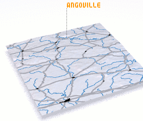 Places with similar names to Angoville, France ::
Disclaimer :: Information on this page comes without warranty of any kind |
||
|
Where is Angoville? Elevation and coordinates ::
Latitude (lat): 48°56'0"N Longitude (lon): 0°23'0"W
Elevation (approx.): 248m (map arrows pan, magnifying glasses zoom) |
||
|
Visiting Angoville? Hotel/Accommodation ::
Book a hotel in Angoville Travel Guide ::
Buy a travel guide for France rental cars ::
car rental offers GPS waypoint ::
download a GPX waypoint (PoI) of Angoville for your GPS receiver
|
||