|
search place name
|
||
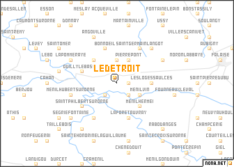
Le Détroit (Basse-Normandie, France)Le Détroit is a town in the Basse-Normandie region of France. An overview map of the region around Le Détroit is displayed below.
regional and 3d topo map of Le Détroit, France ::
Le Détroit airports ::
The nearest airport is CFR - Caen Carpiquet, located 34.9 km north of Le Détroit.
Other airports nearby include DOL - Deauville St Gatien (66.6 km north east), LEH - Le Havre Octeville (80.8 km north east), LVA - Laval Entrammes (97.3 km south), LME - Le Mans Arnage (110.0 km south), Nearby towns ::
Rapilly (1.2km east) //
Les Isles-Bardel (2.2km south east) //
Le Mesnil-Villement (2.2km south west) //
Tréprel (3.7km north) //
Pierrepont (3.9km north) //
Ménil-Vin (3.1km south east) //
Pierrefitte-en-Cinglais (4.4km north west) //
Ménil-Hermei (4.4km south east) //
Les Loges-Saulces (3.7km east) //
Ouilly-le-Basset (4.1km north west) //
Bonnoeil (5.7km north) //
La Forêt-Auvray (5.7km south) //
Saint-Germain-Langot (6.1km north east) //
Bréel (6.1km south west) //
Saint-Philbert-sur-Orne (5.2km south west) //
Ménil-Hubert-sur-Orne (5.2km west) //
Leffard (6.7km north east) //
Angoville (7.8km north) //
Martigny-sur-lʼAnte (6.1km north east) //
La Pommeraye (6.1km north west) //
Cossesseville (6.1km north west) //
Ségrie-Fontaine (7.4km south west) //
Notre-Dame-du-Rocher (8.3km south west) //
Rabodanges (8.9km south east) //
[all distances 'as the bird flies' and approximate]  Places with similar names to Le Détroit, France ::
// La Totorita (CL)
// Lo de Duarte (MX)
Disclaimer :: Information on this page comes without warranty of any kind |
||
|
Where is Le Détroit? Elevation and coordinates ::
Latitude (lat): 48°52'0"N Longitude (lon): 0°21'0"W
Elevation (approx.): 209m (map arrows pan, magnifying glasses zoom) |
||
|
Visiting Le Détroit? Hotel/Accommodation ::
Book a hotel in Le Détroit Travel Guide ::
Buy a travel guide for France rental cars ::
car rental offers GPS waypoint ::
download a GPX waypoint (PoI) of Le Détroit for your GPS receiver
|
||