|
search place name
|
||
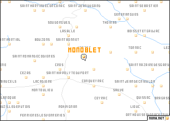
Monoblet (Languedoc-Roussillon, France)Monoblet is a town in the Languedoc-Roussillon region of France. An overview map of the region around Monoblet is displayed below.
regional and 3d topo map of Monoblet, France ::
Monoblet airports ::
The nearest airport is MPL - Montpellier Mediterranee, located 47.5 km south of Monoblet.
Other airports nearby include FNI - Nimes Garons (50.6 km south east), MEN - Mende Brenoux (62.4 km north west), OBS - Aubenas-vals-lanas Ardeche Meridionale (72.0 km north east), AVN - Avignon Caumont (82.4 km east), Nearby towns ::
Vabres (1.9km north) //
Fressac (2.3km south east) //
Saint-Bonnet (4.6km north west) //
Saint-Hippolyte-du-Fort (4.6km south west) //
Conqueyrac (5.7km south) //
Cros (4.4km south west) //
Saint-Félix-de-Pallières (4.4km north east) //
Lasalle (6.2km north west) //
Sainte-Croix-de-Caderle (7.5km north) //
Colognac (6.5km north west) //
Soudorgues (8.4km north west) //
Thoiras (8.4km north east) //
Sauve (9.1km south east) //
[all distances 'as the bird flies' and approximate] 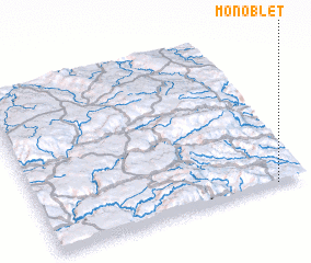 Places with similar names to Monoblet, France ::
// Manbalete (PH)
// Manabalate (MZ)
Disclaimer :: Information on this page comes without warranty of any kind |
||
|
Where is Monoblet? Elevation and coordinates ::
Latitude (lat): 44°0'0"N Longitude (lon): 3°53'0"E
Elevation (approx.): 339m (map arrows pan, magnifying glasses zoom) |
||
|
Visiting Monoblet? Hotel/Accommodation ::
Book a hotel in Monoblet Travel Guide ::
Buy a travel guide for France rental cars ::
car rental offers GPS waypoint ::
download a GPX waypoint (PoI) of Monoblet for your GPS receiver
|
||