|
search place name
|
||
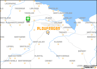
Ploufragan (Bretagne, France)Ploufragan is a town in the Bretagne region of France. An overview map of the region around Ploufragan is displayed below.
regional and 3d topo map of Ploufragan, France ::
Ploufragan airports ::
The nearest airport is SBK - St.-brieuc Armor Armor, located 8.0 km north west of Ploufragan.
Other airports nearby include DNR - Dinard Pleurtuit (53.2 km east), LAI - Lannion (59.0 km north west), MXN - Morlaix Ploujean (77.4 km west), VNE - Vannes Meucon (84.6 km south), Nearby towns ::
Saint-Brieuc (3.7km north) //
Plédran (4.4km south east) //
Saint-Julien (4.4km south west) //
Le Légué (4.4km north east) //
Tréguex (3.7km east) //
Plérin (5.6km north) //
La Méaugon (4.1km north west) //
Cesson (5.2km north east) //
Langueux (5.3km east) //
Le Sépulcre (6.7km north west) //
Plaine-Haute (6.2km south west) //
Trémuson (6.2km north west) //
Le Vallet (7.4km north east) //
La Ville Hervy (8.3km north east) //
Saint-Laurent-Plage (8.3km north east) //
Tréméloir (8.9km north west) //
[all distances 'as the bird flies' and approximate]  Places with similar names to Ploufragan, France ::
// Palafroken (LR)
Disclaimer :: Information on this page comes without warranty of any kind |
||
|
Where is Ploufragan? Elevation and coordinates ::
Latitude (lat): 48°29'0"N Longitude (lon): 2°47'0"W
Elevation (approx.): 117m (map arrows pan, magnifying glasses zoom) |
||
|
Visiting Ploufragan? Hotel/Accommodation ::
Book a hotel in Ploufragan Travel Guide ::
Buy a travel guide for France rental cars ::
car rental offers GPS waypoint ::
download a GPX waypoint (PoI) of Ploufragan for your GPS receiver
|
||