|
search place name
|
||
Tréméloir (Bretagne, France)Tréméloir is a town in the Bretagne region of France. An overview map of the region around Tréméloir is displayed below.
regional and 3d topo map of Tréméloir, France ::

Tréméloir airports ::
The nearest airport is SBK - St.-brieuc Armor Armor, located 1.4 km south of Tréméloir.
Other airports nearby include LAI - Lannion (51.1 km north west), DNR - Dinard Pleurtuit (57.0 km east), MXN - Morlaix Ploujean (71.5 km west), JER - Jersey (87.5 km north east), Nearby towns ::
Le Sépulcre (2.2km south east) //
La Plesse (2.2km north east) //
Trémuson (3.7km south) //
Trégomeur (3.1km north west) //
Plerneuf (4.4km south west) //
Pordic (4.4km north east) //
La Méaugon (5.7km south) //
Binic (5.7km north) //
Lantic (6.1km north west) //
Plérin (5.2km east) //
La Cour (7.5km north) //
Gicquel (7.5km north) //
Plouvara (6.2km south west) //
Saint-Brieuc (6.2km south east) //
La Corderie (6.1km north west) //
La Ville Rouault (6.1km north east) //
Ploufragan (8.9km south east) //
[all distances 'as the bird flies' and approximate] 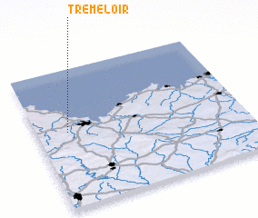 Places with similar names to Tréméloir, France ::
Disclaimer :: Information on this page comes without warranty of any kind |
||
|
Where is Tréméloir? Elevation and coordinates ::
Latitude (lat): 48°33'0"N Longitude (lon): 2°51'0"W
Elevation (approx.): 110m (map arrows pan, magnifying glasses zoom) |
||
|
Visiting Tréméloir? Hotel/Accommodation ::
Book a hotel in Tréméloir Travel Guide ::
Buy a travel guide for France rental cars ::
car rental offers GPS waypoint ::
download a GPX waypoint (PoI) of Tréméloir for your GPS receiver
|
||