|
search place name
|
||
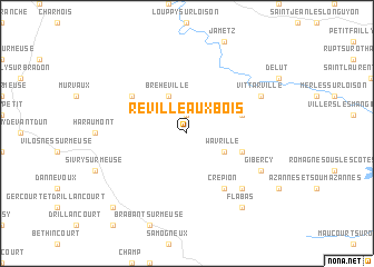
Réville-aux-Bois (Lorraine, France)Réville-aux-Bois is a town in the Lorraine region of France. An overview map of the region around Réville-aux-Bois is displayed below.
regional and 3d topo map of Réville-aux-Bois, France ::
Réville-aux-Bois airports ::
The nearest airport is MZM - Metz Frescaty, located 64.8 km south east of Réville-aux-Bois.
Other airports nearby include LUX - Luxemburg Luxembourg (69.6 km north east), ETZ - Metz Nancy Lorraine (77.4 km south east), RHE - Reims Champagne (94.6 km west), ENC - Nancy Essey (97.5 km south east), Nearby towns ::
Lissey (1.9km north) //
Écurey (1.9km north) //
Bréhéville (3.9km north) //
Étraye (3.0km south east) //
Wavrille (3.0km south east) //
Peuvillers (4.1km north east) //
Damvillers (4.1km south east) //
Brandeville (5.2km north west) //
Crépion (6.1km south east) //
Moirey (6.6km south east) //
Vittarville (6.1km north east) //
Gibercy (6.1km south east) //
Flabas (8.3km south east) //
Consenvoye (8.8km south west) //
[all distances 'as the bird flies' and approximate]  Places with similar names to Réville-aux-Bois, France :: Disclaimer :: Information on this page comes without warranty of any kind |
||
|
Where is Réville-aux-Bois? Elevation and coordinates ::
Latitude (lat): 49°21'0"N Longitude (lon): 5°21'0"E
Elevation (approx.): 302m (map arrows pan, magnifying glasses zoom) |
||
|
Visiting Réville-aux-Bois? Hotel/Accommodation ::
Book a hotel in Réville-aux-Bois Travel Guide ::
Buy a travel guide for France rental cars ::
car rental offers GPS waypoint ::
download a GPX waypoint (PoI) of Réville-aux-Bois for your GPS receiver
|
||