|
search place name
|
||
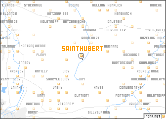
Saint-Hubert (Lorraine, France)Saint-Hubert is a town in the Lorraine region of France. An overview map of the region around Saint-Hubert is displayed below.
regional and 3d topo map of Saint-Hubert, France ::
Saint-Hubert airports ::
The nearest airport is MZM - Metz Frescaty, located 23.2 km south west of Saint-Hubert.
Other airports nearby include ETZ - Metz Nancy Lorraine (28.6 km south), LUX - Luxemburg Luxembourg (44.6 km north), SCN - Saarbruecken Saarbrucken (56.6 km east), ENC - Nancy Essey (60.7 km south), Nearby towns ::
Bettelainville (2.4km west) //
Luttange (3.9km north) //
Aboncourt (3.9km north) //
Vigy (4.4km south west) //
Vry (5.6km south) //
Saint-Bernard (4.1km north east) //
Budange (5.7km north) //
Hombourg-Budange (7.4km north) //
Metzeresche (7.5km north) //
Sanry-lès-Vigy (6.6km south west) //
Avancy (7.8km south) //
Sainte-Barbe (7.8km south) //
Hayes (7.8km south) //
Vrémy (8.3km south west) //
Ebersviller (7.4km north east) //
Volstroff (8.9km north west) //
Dalstein (8.9km north east) //
[all distances 'as the bird flies' and approximate]  Places with similar names to Saint-Hubert, France ::
// Sint Hubert (NL)
// Saint-Hubert (CA)
// Saint-Hubert (FR)
// Saint-Hubert (FR)
// Saint-Hubert (BE)
Disclaimer :: Information on this page comes without warranty of any kind |
||
|
Where is Saint-Hubert? Elevation and coordinates ::
Latitude (lat): 49°14'0"N Longitude (lon): 6°20'0"E
Elevation (approx.): 232m (map arrows pan, magnifying glasses zoom) |
||
|
Visiting Saint-Hubert? Hotel/Accommodation ::
Book a hotel in Saint-Hubert Travel Guide ::
Buy a travel guide for France rental cars ::
car rental offers GPS waypoint ::
download a GPX waypoint (PoI) of Saint-Hubert for your GPS receiver
|
||