|
search place name
|
||
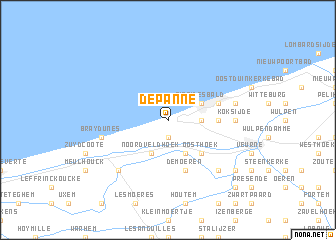
De Panne (West-Vlaanderen, Belgium)De Panne is a town in the West-Vlaanderen region of Belgium. An overview map of the region around De Panne is displayed below.
regional and 3d topo map of De Panne, Belgium ::
De Panne airports ::
The nearest airport is OST - Oostende, located 22.4 km north east of De Panne.
Other airports nearby include CQF - Calais Dunkerque (46.7 km west), QKT - Kortrijk-vevelgem Wevelgem (53.8 km south east), LIL - Lille Lesquin (69.7 km south east), MSE - Manston (90.5 km west), Nearby towns ::
Duinhoek (1.9km south) //
De Zeepanne (2.3km east) //
Kerkepanne (2.3km east) //
Noordveldhoek (3.9km south) //
Adinkerke (3.9km south) //
Sint-Idesbald (3.0km north east) //
Oosthoek (4.4km south east) //
Hogenblekker (3.5km east) //
Koksijde-Bad (4.0km north east) //
De Moeren (5.7km south) //
Koksijde (4.7km east) //
Bray-Dunes (5.0km west) //
Galopen (5.0km east) //
Bewesterpoort (6.6km south east) //
Ghyvelde (6.6km south west) //
Bulskamp (7.3km south east) //
Moerhoek (8.8km south east) //
[all distances 'as the bird flies' and approximate] 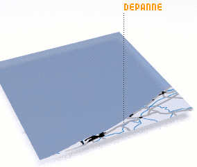 Places with similar names to De Panne, Belgium ::
Disclaimer :: Information on this page comes without warranty of any kind |
||
|
Where is De Panne? Elevation and coordinates ::
Latitude (lat): 51°6'0"N Longitude (lon): 2°35'0"E
Elevation (approx.): 9m (map arrows pan, magnifying glasses zoom) |
||
|
Visiting De Panne? Hotel/Accommodation ::
Book a hotel in De Panne Travel Guide ::
Buy a travel guide for Belgium rental cars ::
car rental offers GPS waypoint ::
download a GPX waypoint (PoI) of De Panne for your GPS receiver
|
||