|
search place name
|
||
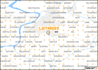
Luithagen (Antwerpen, Belgium)Luithagen is a town in the Antwerpen region of Belgium. An overview map of the region around Luithagen is displayed below.
regional and 3d topo map of Luithagen, Belgium ::
Luithagen airports ::
The nearest airport is ANR - Antwerp Deurne, located 3.2 km north east of Luithagen.
Other airports nearby include BRU - Brussels Natl (Melsbroek) (29.7 km south), WOE - Woensdrecht (32.1 km north), EIN - Eindhoven (72.8 km north east), CRL - Charleroi Brussels South (78.7 km south), Nearby towns ::
Slijkhoek (1.2km west) //
Eikelbos (1.2km west) //
Rooi (1.9km north) //
Mussenborg (1.2km east) //
Oude God (1.2km east) //
Boerenleger (1.9km south) //
Molenveld (2.2km north west) //
Oosterveld (2.2km north west) //
Waasdonk (2.2km north east) //
Drie Eiken (2.2km south west) //
Edegem (2.2km south east) //
Buisegem (2.2km south east) //
Wilrijk (2.3km west) //
Kerkeveld (2.3km west) //
Zurenborg (3.7km north) //
Berchem (3.7km north) //
Mortsel (2.3km east) //
Kretenburg (2.3km east) //
Kantekrooi (2.3km east) //
Boonwit (3.7km south) //
Nachtegaalshoek (3.0km north west) //
Kruishoek (3.0km north west) //
Stenebrug (3.9km north) //
Groenenhoek (3.9km north) //
Kleine Meil (3.0km south east) //
Hove (3.0km south east) //
Kontich (3.9km south) //
Silsburg (4.4km north east) //
Drie Koningen (4.4km north east) //
[all distances 'as the bird flies' and approximate]  Places with similar names to Luithagen, Belgium ::
// Lithoijen (NL)
Disclaimer :: Information on this page comes without warranty of any kind |
||
|
Where is Luithagen? Elevation and coordinates ::
Latitude (lat): 51°10'0"N Longitude (lon): 4°26'0"E
Elevation (approx.): 18m (map arrows pan, magnifying glasses zoom) |
||
|
Visiting Luithagen? Hotel/Accommodation ::
Book a hotel in Luithagen Travel Guide ::
Buy a travel guide for Belgium rental cars ::
car rental offers GPS waypoint ::
download a GPX waypoint (PoI) of Luithagen for your GPS receiver
|
||