|
search place name
|
||
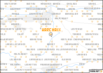
Warchaix (Hainaut, Belgium)Warchaix is a town in the Hainaut region of Belgium. An overview map of the region around Warchaix is displayed below.
regional and 3d topo map of Warchaix, Belgium ::
Warchaix airports ::
The nearest airport is CRL - Charleroi Brussels South, located 35.6 km east of Warchaix.
Other airports nearby include LIL - Lille Lesquin (65.4 km west), BRU - Brussels Natl (Melsbroek) (68.3 km north east), QKT - Kortrijk-vevelgem Wevelgem (72.4 km north west), ANR - Antwerp Deurne (96.2 km north), Nearby towns ::
Ihy (1.9km south) //
Harveng (2.2km north east) //
Asquillies (2.2km north west) //
Maladrie (2.2km north west) //
Bonnet (3.7km south) //
Bougnies (2.4km west) //
Havay (3.9km south) //
Quévy-le-Grand (3.9km south) //
La Sablonnière (3.9km south) //
Harmignies (3.0km north east) //
Quévy-le-Petit (3.0km south west) //
Spiennes (3.9km north) //
Nouvelles (3.9km north) //
Mesvin (3.9km north) //
Le Bocage (3.9km north) //
Trou Barbet (4.4km south east) //
Ciply (4.4km north west) //
Bois Bourdon (5.6km south) //
Bettignies (5.6km south) //
Genly (3.5km west) //
Mont Panisel (5.6km north) //
Montliaux (4.0km south east) //
Blairon (4.0km south west) //
Bommeteau (4.0km south west) //
Waréchaix (5.7km south) //
Gognies-Chaussée (5.7km south) //
Le Bord des Rues (5.7km south) //
Noirchain (4.0km north west) //
Hyon (5.7km north) //
[all distances 'as the bird flies' and approximate]  Places with similar names to Warchaix, Belgium ::
Disclaimer :: Information on this page comes without warranty of any kind |
||
|
Where is Warchaix? Elevation and coordinates ::
Latitude (lat): 50°23'0"N Longitude (lon): 3°58'0"E
Elevation (approx.): 77m (map arrows pan, magnifying glasses zoom) |
||
|
Visiting Warchaix? Hotel/Accommodation ::
Book a hotel in Warchaix Travel Guide ::
Buy a travel guide for Belgium rental cars ::
car rental offers GPS waypoint ::
download a GPX waypoint (PoI) of Warchaix for your GPS receiver
|
||