|
search place name
|
||
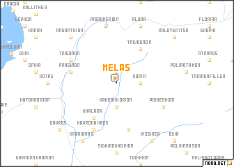
Melás (Piraiévs, Greece)Melás is a town in the Piraiévs region of Greece. An overview map of the region around Melás is displayed below.
regional and 3d topo map of Melás, Greece ::
Melás airports ::
The nearest airport is KSO - Kastoria Aristotelis, located 28.2 km south of Melás.
Other airports nearby include KZI - Kozani Filippos (66.9 km south east), OHD - Ohrid (69.2 km north west), IOA - Ioannina (117.7 km south), SKP - Skopje (143.2 km north), Nearby towns ::
Áno Melás (1.9km north) //
Makrokhórion (3.7km south) //
Korifí (2.8km east) //
Trívounon (6.2km north east) //
Khálara (6.2km south west) //
Áyios Andónios (7.5km south) //
Prásinon (5.9km west) //
Poimenikón (6.7km south east) //
Trígonon (6.7km north west) //
Mavrókambos (7.9km south) //
Andartikón (9.3km north west) //
[all distances 'as the bird flies' and approximate] 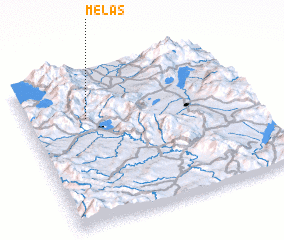 Places with similar names to Melás, Greece ::
Disclaimer :: Information on this page comes without warranty of any kind |
||
|
Where is Melás? Elevation and coordinates ::
Latitude (lat): 40°42'0"N Longitude (lon): 21°16'0"E
Elevation (approx.): 1025m (map arrows pan, magnifying glasses zoom) |
||
|
Visiting Melás? Hotel/Accommodation ::
Book a hotel in Melás Travel Guide ::
Buy a travel guide for Greece rental cars ::
car rental offers GPS waypoint ::
download a GPX waypoint (PoI) of Melás for your GPS receiver
|
||