|
search place name
|
||
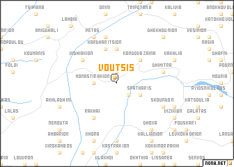
Voútsis (Piraiévs, Greece)Voútsis is a town in the Piraiévs region of Greece. An overview map of the region around Voútsis is displayed below.
regional and 3d topo map of Voútsis, Greece ::
Voútsis airports ::
The nearest airport is PYR - Andravida, located 53.3 km west of Voútsis.
Other airports nearby include GPA - Patras Araxos (57.7 km north west), KLX - Kalamata (78.8 km south), ZTH - Zakynthos Dionysios Solomos (86.6 km west), AGQ - Agrinion (103.1 km north west), Nearby towns ::
Pelékion (1.9km north) //
Ergotázion Ládhonos (2.4km south east) //
Monastirákion (2.9km west) //
Spátharis (3.5km south east) //
Kondovázaina (4.7km north east) //
Velimákhion (5.6km north) //
Kardharítsion (5.7km north) //
Vidhiákion (5.7km north west) //
Rákhai (6.3km south west) //
Dhímitra (6.1km east) //
Paralongoí (7.6km north) //
Pétas (8.0km north) //
Skoúndon (6.9km south east) //
Dhóxa (8.6km south east) //
Dhekhoúnion (9.4km north east) //
[all distances 'as the bird flies' and approximate] 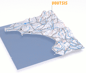 Places with similar names to Voútsis, Greece ::
Disclaimer :: Information on this page comes without warranty of any kind |
||
|
Where is Voútsis? Elevation and coordinates ::
Latitude (lat): 37°46'0"N Longitude (lon): 21°52'0"E
Elevation (approx.): 455m (map arrows pan, magnifying glasses zoom) |
||
|
Visiting Voútsis? Hotel/Accommodation ::
Book a hotel in Voútsis Travel Guide ::
Buy a travel guide for Greece rental cars ::
car rental offers GPS waypoint ::
download a GPX waypoint (PoI) of Voútsis for your GPS receiver
|
||