|
search place name
|
||
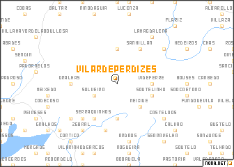
Vilar de Perdizes (Vila Real, Portugal)Vilar de Perdizes is a town in the Vila Real region of Portugal. An overview map of the region around Vilar de Perdizes is displayed below.
regional and 3d topo map of Vilar de Perdizes, Portugal ::
Vilar de Perdizes airports ::
The nearest airport is VRL - Vila Real, located 64.3 km south of Vilar de Perdizes.
Other airports nearby include BGC - Braganca (76.9 km east), VGO - Vigo (92.5 km north west), OPO - Porto (110.1 km south west), SCQ - Santiago (132.9 km north west), Nearby towns ::
Santo André (3.3km north west) //
Solveira (3.3km south west) //
Meixide (4.6km south east) //
Gironda (5.6km north) //
Videferre (4.1km east) //
Pedrário (5.6km south) //
Soutelinho (4.5km south east) //
San Millán (6.2km north east) //
Serraquinhos (6.2km south west) //
Gralhas (5.5km west) //
Antigo de Arcos (7.5km south) //
Sepeda (6.9km south west) //
San Cristóbal (7.8km north east) //
Castelãos (7.8km south east) //
Zebral (8.5km south west) //
La Magdalena (8.5km north east) //
Aldeia Nova de São Mateus (7.8km south west) //
[all distances 'as the bird flies' and approximate] 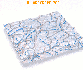 Places with similar names to Vilar de Perdizes, Portugal :: Disclaimer :: Information on this page comes without warranty of any kind |
||
|
Where is Vilar de Perdizes? Elevation and coordinates ::
Latitude (lat): 41°51'0"N Longitude (lon): 7°38'0"W
Elevation (approx.): 796m (map arrows pan, magnifying glasses zoom) |
||
|
Visiting Vilar de Perdizes? Hotel/Accommodation ::
Book a hotel in Vilar de Perdizes Travel Guide ::
Buy a travel guide for Portugal rental cars ::
car rental offers GPS waypoint ::
download a GPX waypoint (PoI) of Vilar de Perdizes for your GPS receiver
|
||